You are here: Home > Network List > XD14 - Illuminating the architecture of the greater Mount St. Helens magmatic systems f Stations List
> Station MN10 "Mount St Helens, WA" > Earthquake Result Viewer
MN10 "Mount St Helens, WA" - Earthquake Result Viewer
| Earthquake location: |
Kuril Islands |
| Earthquake latitude/longitude: |
44.0/147.9 |
| Earthquake time(UTC): |
2015/07/07 (188) 05:10:27 GMT |
| Earthquake Depth: |
38 km |
| Earthquake Magnitude: |
6.3 MO |
| Earthquake Catalog/Contributor: |
NEIC PDE/NEIC ALERT |
|
| Network: |
XD Illuminating the architecture of the greater Mount St. Helens magmatic systems f |
| Station: |
MN10 "Mount St Helens, WA" |
| Lat/Lon: |
45.98 N/121.68 W |
| Elevation: |
1091 m |
|
| Distance: |
60.5 deg |
| Az: |
53.253 deg |
| Baz: |
303.954 deg |
| Ray Param: |
0.061430413 |
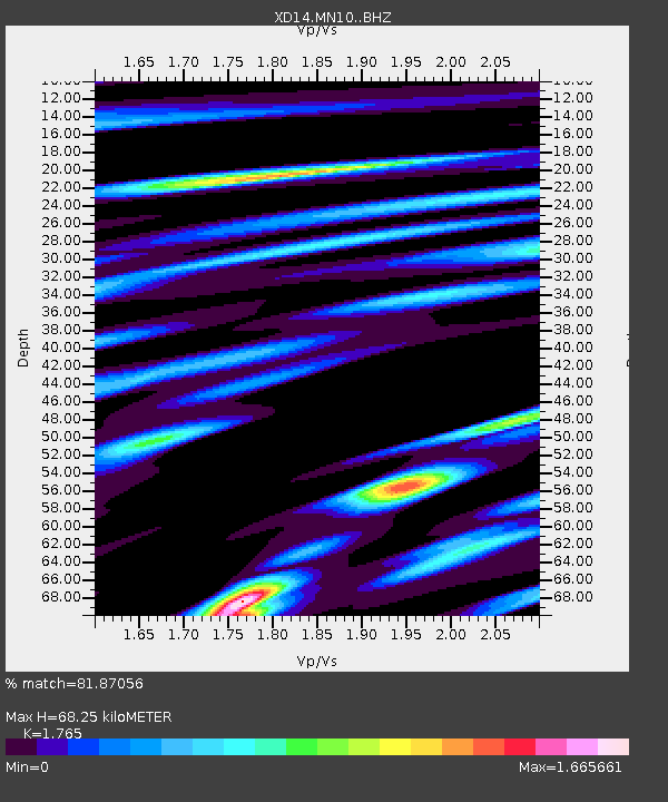
| Estimated Moho Depth: |
68.25 km |
| Estimated Crust Vp/Vs: |
1.76 |
| Assumed Crust Vp: |
6.597 km/s |
| Estimated Crust Vs: |
3.738 km/s |
| Estimated Crust Poisson's Ratio: |
0.26 |
|
| Radial Match: |
81.87056 % |
| Radial Bump: |
400 |
| Transverse Match: |
71.273384 % |
| Transverse Bump: |
400 |
| SOD ConfigId: |
7422571 |
| Insert Time: |
2019-04-19 16:23:23.622 +0000 |
| GWidth: |
2.5 |
| Max Bumps: |
400 |
| Tol: |
0.001 |
|

Signal To Noise
| Channel | StoN | STA | LTA |
| XD:MN10: :BHZ:20150707T05:20:01.58501Z | 27.493797 | 2.5579054E-6 | 9.303572E-8 |
| XD:MN10: :BHN:20150707T05:20:01.58501Z | 4.9721255 | 7.9516985E-7 | 1.5992553E-7 |
| XD:MN10: :BHE:20150707T05:20:01.58501Z | 10.467231 | 1.2573275E-6 | 1.2012036E-7 |
| Arrivals |
| Ps | 8.3 SECOND |
| PpPs | 27 SECOND |
| PsPs/PpSs | 36 SECOND |


