You are here: Home > Network List > XO11 - Ozark Illinois, Indiana and Kentucky ES Flexible Array Stations List
> Station KJ50 KJ50 of OIINK Flexarray > Earthquake Result Viewer
KJ50 KJ50 of OIINK Flexarray - Earthquake Result Viewer
| Earthquake location: |
Kuril Islands |
| Earthquake latitude/longitude: |
44.0/147.9 |
| Earthquake time(UTC): |
2015/07/07 (188) 05:10:27 GMT |
| Earthquake Depth: |
38 km |
| Earthquake Magnitude: |
6.3 MO |
| Earthquake Catalog/Contributor: |
NEIC PDE/NEIC ALERT |
|
| Network: |
XO Ozark Illinois, Indiana and Kentucky ES Flexible Array |
| Station: |
KJ50 KJ50 of OIINK Flexarray |
| Lat/Lon: |
37.05 N/84.58 W |
| Elevation: |
255 m |
|
| Distance: |
86.3 deg |
| Az: |
39.508 deg |
| Baz: |
324.973 deg |
| Ray Param: |
0.04406304 |
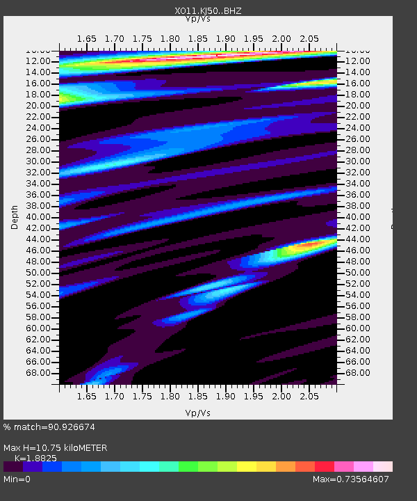
| Estimated Moho Depth: |
10.75 km |
| Estimated Crust Vp/Vs: |
1.88 |
| Assumed Crust Vp: |
6.476 km/s |
| Estimated Crust Vs: |
3.44 km/s |
| Estimated Crust Poisson's Ratio: |
0.30 |
|
| Radial Match: |
90.926674 % |
| Radial Bump: |
400 |
| Transverse Match: |
86.80545 % |
| Transverse Bump: |
400 |
| SOD ConfigId: |
7422571 |
| Insert Time: |
2019-04-19 16:24:01.457 +0000 |
| GWidth: |
2.5 |
| Max Bumps: |
400 |
| Tol: |
0.001 |
|

Signal To Noise
| Channel | StoN | STA | LTA |
| XO:KJ50: :BHZ:20150707T05:22:33.200Z | 25.668898 | 3.4412274E-6 | 1.3406213E-7 |
| XO:KJ50: :BHN:20150707T05:22:33.200Z | 6.2618227 | 6.512618E-7 | 1.04005146E-7 |
| XO:KJ50: :BHE:20150707T05:22:33.200Z | 2.3459823 | 3.7058894E-7 | 1.5796749E-7 |
| Arrivals |
| Ps | 1.5 SECOND |
| PpPs | 4.7 SECOND |
| PsPs/PpSs | 6.2 SECOND |


