You are here: Home > Network List > YN10 - San Jacinto Fault Zone Stations List
> Station JFN4 JFN4 > Earthquake Result Viewer
JFN4 JFN4 - Earthquake Result Viewer
| Earthquake location: |
Kuril Islands |
| Earthquake latitude/longitude: |
44.0/147.9 |
| Earthquake time(UTC): |
2015/07/07 (188) 05:10:27 GMT |
| Earthquake Depth: |
38 km |
| Earthquake Magnitude: |
6.3 MO |
| Earthquake Catalog/Contributor: |
NEIC PDE/NEIC ALERT |
|
| Network: |
YN San Jacinto Fault Zone |
| Station: |
JFN4 JFN4 |
| Lat/Lon: |
33.42 N/116.40 W |
| Elevation: |
646 m |
|
| Distance: |
71.3 deg |
| Az: |
61.447 deg |
| Baz: |
310.699 deg |
| Ray Param: |
0.054326702 |
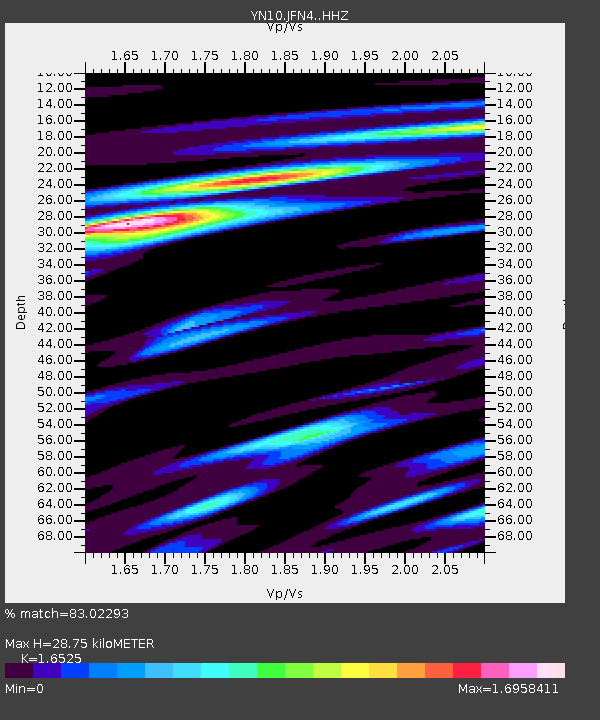
| Estimated Moho Depth: |
28.75 km |
| Estimated Crust Vp/Vs: |
1.65 |
| Assumed Crust Vp: |
6.264 km/s |
| Estimated Crust Vs: |
3.79 km/s |
| Estimated Crust Poisson's Ratio: |
0.21 |
|
| Radial Match: |
83.02293 % |
| Radial Bump: |
400 |
| Transverse Match: |
77.18222 % |
| Transverse Bump: |
400 |
| SOD ConfigId: |
7422571 |
| Insert Time: |
2019-04-19 16:24:35.659 +0000 |
| GWidth: |
2.5 |
| Max Bumps: |
400 |
| Tol: |
0.001 |
|

Signal To Noise
| Channel | StoN | STA | LTA |
| YN:JFN4: :HHZ:20150707T05:21:11.194019Z | 28.328936 | 1.8663607E-6 | 6.588178E-8 |
| YN:JFN4: :HHN:20150707T05:21:11.194019Z | 4.8483496 | 6.0824294E-7 | 1.254536E-7 |
| YN:JFN4: :HHE:20150707T05:21:11.194019Z | 7.5654664 | 6.4688925E-7 | 8.550553E-8 |
| Arrivals |
| Ps | 3.1 SECOND |
| PpPs | 12 SECOND |
| PsPs/PpSs | 15 SECOND |


