You are here: Home > Network List > CI - Caltech Regional Seismic Network Stations List
> Station MPM Manuel Prospect Mine, California, USA > Earthquake Result Viewer
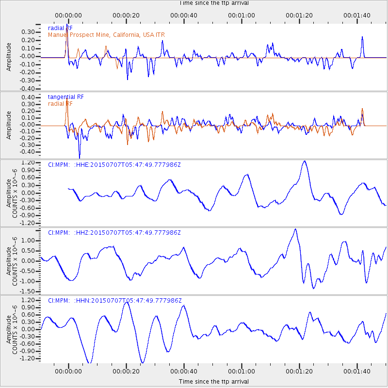
MPM Manuel Prospect Mine, California, USA - Earthquake Result Viewer
*The percent match for this event was below the threshold and hence no stack was calculated.
| Earthquake location: |
East Of North Island, N.Z. |
| Earthquake latitude/longitude: |
-35.4/-179.6 |
| Earthquake time(UTC): |
2015/07/07 (188) 05:35:14 GMT |
| Earthquake Depth: |
10 km |
| Earthquake Magnitude: |
5.6 MWW, 5.7 MWC |
| Earthquake Catalog/Contributor: |
NEIC PDE/NEIC COMCAT |
|
| Network: |
CI Caltech Regional Seismic Network |
| Station: |
MPM Manuel Prospect Mine, California, USA |
| Lat/Lon: |
36.06 N/117.49 W |
| Elevation: |
185 m |
|
| Distance: |
91.7 deg |
| Az: |
45.775 deg |
| Baz: |
226.242 deg |
| Ray Param: |
$rayparam |
*The percent match for this event was below the threshold and hence was not used in the summary stack. |
|
| Radial Match: |
48.66037 % |
| Radial Bump: |
347 |
| Transverse Match: |
78.24796 % |
| Transverse Bump: |
400 |
| SOD ConfigId: |
7422571 |
| Insert Time: |
2019-04-19 16:26:17.826 +0000 |
| GWidth: |
2.5 |
| Max Bumps: |
400 |
| Tol: |
0.001 |
|
Signal To Noise
| Channel | StoN | STA | LTA |
| CI:MPM: :HHZ:20150707T05:47:49.777986Z | 3.9426427 | 7.6100486E-7 | 1.9301898E-7 |
| CI:MPM: :HHN:20150707T05:47:49.777986Z | 0.9314924 | 3.711664E-7 | 3.9846424E-7 |
| CI:MPM: :HHE:20150707T05:47:49.777986Z | 2.7474496 | 3.6505287E-7 | 1.3286973E-7 |
| Arrivals |
| Ps | |
| PpPs | |
| PsPs/PpSs | |


