You are here: Home > Network List > US - United States National Seismic Network Stations List
> Station WMOK Wichita Mountains, Oklahoma, USA > Earthquake Result Viewer
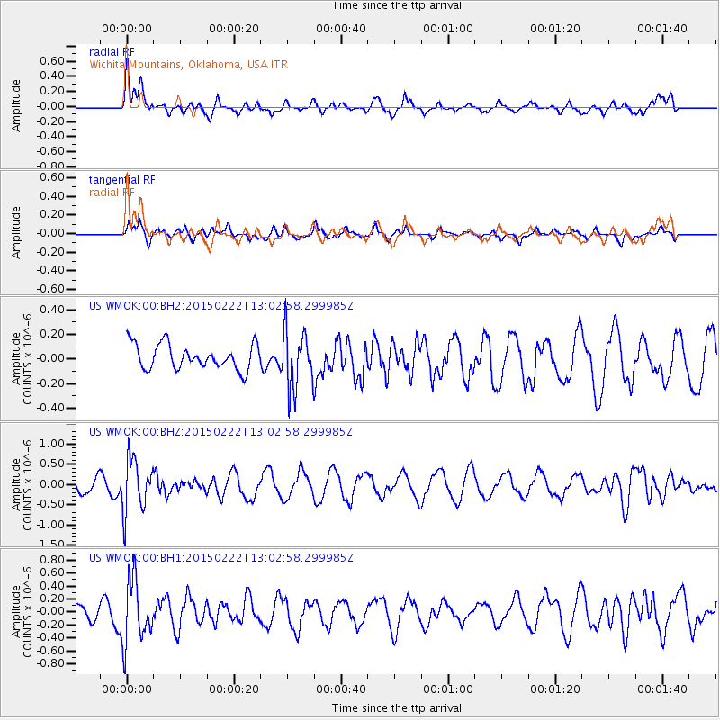
WMOK Wichita Mountains, Oklahoma, USA - Earthquake Result Viewer
*The percent match for this event was below the threshold and hence no stack was calculated.
| Earthquake location: |
Colombia |
| Earthquake latitude/longitude: |
2.7/-76.5 |
| Earthquake time(UTC): |
2015/02/22 (053) 12:56:24 GMT |
| Earthquake Depth: |
151 km |
| Earthquake Magnitude: |
5.6 MB |
| Earthquake Catalog/Contributor: |
NEIC PDE/NEIC COMCAT |
|
| Network: |
US United States National Seismic Network |
| Station: |
WMOK Wichita Mountains, Oklahoma, USA |
| Lat/Lon: |
34.74 N/98.78 W |
| Elevation: |
486 m |
|
| Distance: |
38.1 deg |
| Az: |
329.555 deg |
| Baz: |
142.076 deg |
| Ray Param: |
$rayparam |
*The percent match for this event was below the threshold and hence was not used in the summary stack. |
|
| Radial Match: |
70.38359 % |
| Radial Bump: |
400 |
| Transverse Match: |
63.20613 % |
| Transverse Bump: |
400 |
| SOD ConfigId: |
872571 |
| Insert Time: |
2015-03-08 13:10:11.859 +0000 |
| GWidth: |
2.5 |
| Max Bumps: |
400 |
| Tol: |
0.001 |
|
Signal To Noise
| Channel | StoN | STA | LTA |
| US:WMOK:00:BHZ:20150222T13:02:58.299985Z | 3.0908732 | 6.515933E-7 | 2.1081205E-7 |
| US:WMOK:00:BH1:20150222T13:02:58.299985Z | 2.876238 | 4.865631E-7 | 1.6916651E-7 |
| US:WMOK:00:BH2:20150222T13:02:58.299985Z | 2.3455725 | 2.349718E-7 | 1.00176734E-7 |
| Arrivals |
| Ps | |
| PpPs | |
| PsPs/PpSs | |


