You are here: Home > Network List > TA - USArray Transportable Network (new EarthScope stations) Stations List
> Station O48A Farmland, IN, USA > Earthquake Result Viewer
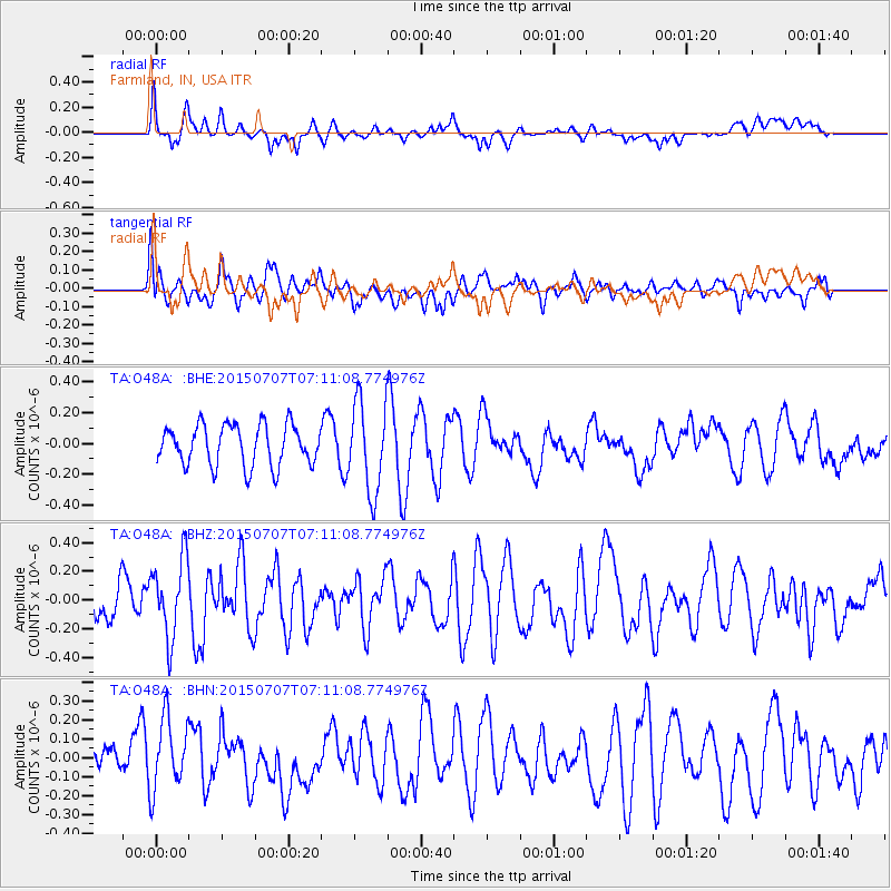
O48A Farmland, IN, USA - Earthquake Result Viewer
*The percent match for this event was below the threshold and hence no stack was calculated.
| Earthquake location: |
Central East Pacific Rise |
| Earthquake latitude/longitude: |
-13.3/-111.6 |
| Earthquake time(UTC): |
2015/07/07 (188) 07:01:44 GMT |
| Earthquake Depth: |
21 km |
| Earthquake Magnitude: |
5.9 MWW, 5.9 MWC |
| Earthquake Catalog/Contributor: |
NEIC PDE/NEIC COMCAT |
|
| Network: |
TA USArray Transportable Network (new EarthScope stations) |
| Station: |
O48A Farmland, IN, USA |
| Lat/Lon: |
40.26 N/85.16 W |
| Elevation: |
300 m |
|
| Distance: |
58.7 deg |
| Az: |
23.538 deg |
| Baz: |
210.53 deg |
| Ray Param: |
$rayparam |
*The percent match for this event was below the threshold and hence was not used in the summary stack. |
|
| Radial Match: |
73.98998 % |
| Radial Bump: |
400 |
| Transverse Match: |
33.807007 % |
| Transverse Bump: |
330 |
| SOD ConfigId: |
7422571 |
| Insert Time: |
2019-04-19 16:38:29.246 +0000 |
| GWidth: |
2.5 |
| Max Bumps: |
400 |
| Tol: |
0.001 |
|
Signal To Noise
| Channel | StoN | STA | LTA |
| TA:O48A: :BHZ:20150707T07:11:08.774976Z | 1.7158426 | 2.739524E-7 | 1.5966056E-7 |
| TA:O48A: :BHN:20150707T07:11:08.774976Z | 1.6113468 | 1.8590592E-7 | 1.15373005E-7 |
| TA:O48A: :BHE:20150707T07:11:08.774976Z | 2.444228 | 3.299428E-7 | 1.3498855E-7 |
| Arrivals |
| Ps | |
| PpPs | |
| PsPs/PpSs | |


