You are here: Home > Network List > TA - USArray Transportable Network (new EarthScope stations) Stations List
> Station WHTX Lake Whitney, Meridian, TX, USA > Earthquake Result Viewer
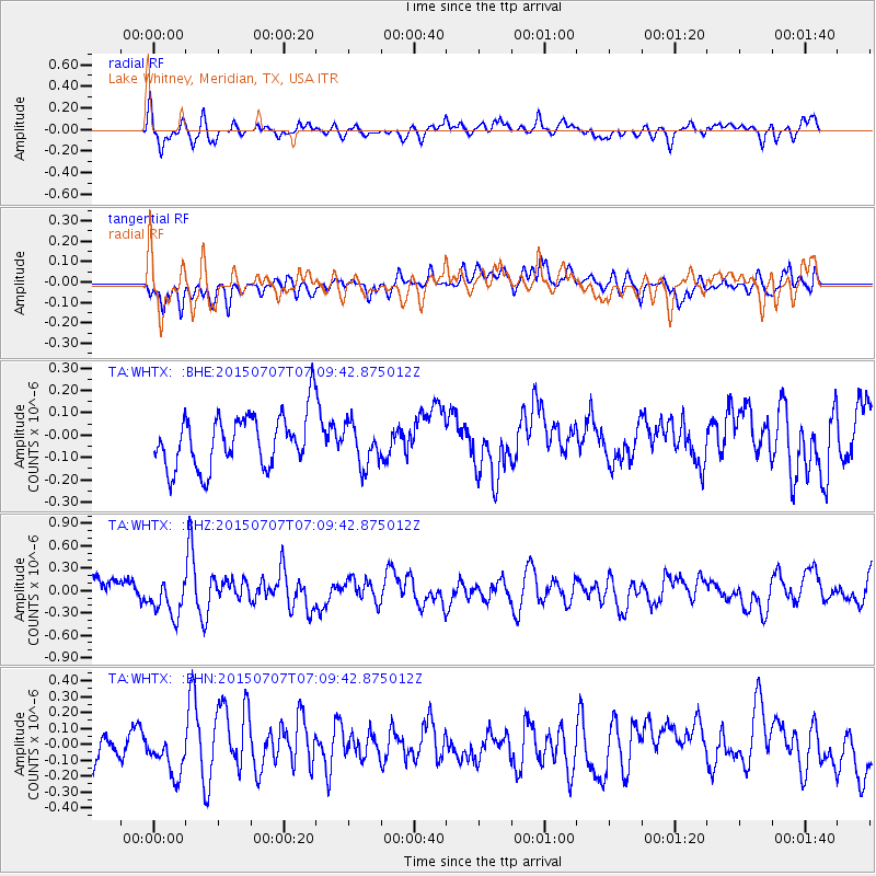
WHTX Lake Whitney, Meridian, TX, USA - Earthquake Result Viewer
*The percent match for this event was below the threshold and hence no stack was calculated.
| Earthquake location: |
Central East Pacific Rise |
| Earthquake latitude/longitude: |
-13.3/-111.6 |
| Earthquake time(UTC): |
2015/07/07 (188) 07:01:44 GMT |
| Earthquake Depth: |
21 km |
| Earthquake Magnitude: |
5.9 MWW, 5.9 MWC |
| Earthquake Catalog/Contributor: |
NEIC PDE/NEIC COMCAT |
|
| Network: |
TA USArray Transportable Network (new EarthScope stations) |
| Station: |
WHTX Lake Whitney, Meridian, TX, USA |
| Lat/Lon: |
31.99 N/97.46 W |
| Elevation: |
190 m |
|
| Distance: |
47.1 deg |
| Az: |
16.521 deg |
| Baz: |
199.013 deg |
| Ray Param: |
$rayparam |
*The percent match for this event was below the threshold and hence was not used in the summary stack. |
|
| Radial Match: |
72.3921 % |
| Radial Bump: |
400 |
| Transverse Match: |
46.08216 % |
| Transverse Bump: |
400 |
| SOD ConfigId: |
7422571 |
| Insert Time: |
2019-04-19 16:38:35.291 +0000 |
| GWidth: |
2.5 |
| Max Bumps: |
400 |
| Tol: |
0.001 |
|
Signal To Noise
| Channel | StoN | STA | LTA |
| TA:WHTX: :BHZ:20150707T07:09:42.875012Z | 2.338797 | 2.499105E-7 | 1.0685429E-7 |
| TA:WHTX: :BHN:20150707T07:09:42.875012Z | 1.5952237 | 1.254616E-7 | 7.864828E-8 |
| TA:WHTX: :BHE:20150707T07:09:42.875012Z | 0.7904199 | 9.754682E-8 | 1.234114E-7 |
| Arrivals |
| Ps | |
| PpPs | |
| PsPs/PpSs | |


