You are here: Home > Network List > TA - USArray Transportable Network (new EarthScope stations) Stations List
> Station I23K Minto, Yukon-Koyukuk, AK, USA > Earthquake Result Viewer
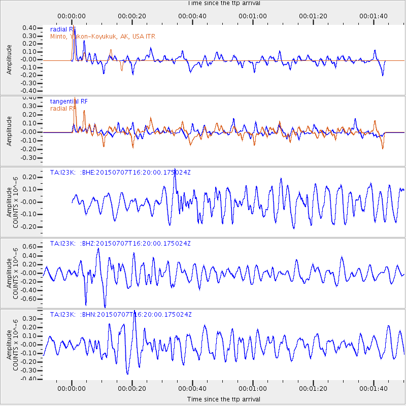
I23K Minto, Yukon-Koyukuk, AK, USA - Earthquake Result Viewer
*The percent match for this event was below the threshold and hence no stack was calculated.
| Earthquake location: |
Central East Pacific Rise |
| Earthquake latitude/longitude: |
-13.4/-111.3 |
| Earthquake time(UTC): |
2015/07/07 (188) 16:08:03 GMT |
| Earthquake Depth: |
10 km |
| Earthquake Magnitude: |
5.7 MWW, 5.7 MWC |
| Earthquake Catalog/Contributor: |
NEIC PDE/NEIC COMCAT |
|
| Network: |
TA USArray Transportable Network (new EarthScope stations) |
| Station: |
I23K Minto, Yukon-Koyukuk, AK, USA |
| Lat/Lon: |
65.15 N/149.36 W |
| Elevation: |
149 m |
|
| Distance: |
83.4 deg |
| Az: |
344.793 deg |
| Baz: |
142.841 deg |
| Ray Param: |
$rayparam |
*The percent match for this event was below the threshold and hence was not used in the summary stack. |
|
| Radial Match: |
60.13408 % |
| Radial Bump: |
400 |
| Transverse Match: |
48.699738 % |
| Transverse Bump: |
400 |
| SOD ConfigId: |
7422571 |
| Insert Time: |
2019-04-19 16:51:11.681 +0000 |
| GWidth: |
2.5 |
| Max Bumps: |
400 |
| Tol: |
0.001 |
|
Signal To Noise
| Channel | StoN | STA | LTA |
| TA:I23K: :BHZ:20150707T16:20:00.175024Z | 2.8120818 | 2.2517315E-7 | 8.007347E-8 |
| TA:I23K: :BHN:20150707T16:20:00.175024Z | 0.50742674 | 4.7703857E-8 | 9.401131E-8 |
| TA:I23K: :BHE:20150707T16:20:00.175024Z | 2.076458 | 1.07029635E-7 | 5.154433E-8 |
| Arrivals |
| Ps | |
| PpPs | |
| PsPs/PpSs | |


