You are here: Home > Network List > TA - USArray Transportable Network (new EarthScope stations) Stations List
> Station MSTX Muleshoe, TX, USA > Earthquake Result Viewer
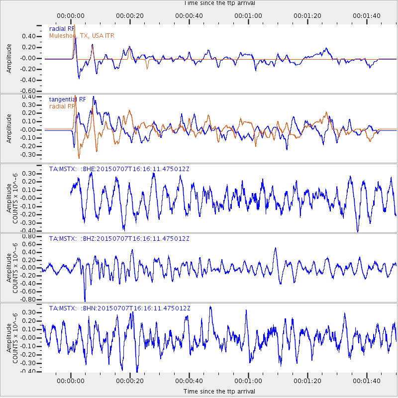
MSTX Muleshoe, TX, USA - Earthquake Result Viewer
*The percent match for this event was below the threshold and hence no stack was calculated.
| Earthquake location: |
Central East Pacific Rise |
| Earthquake latitude/longitude: |
-13.4/-111.3 |
| Earthquake time(UTC): |
2015/07/07 (188) 16:08:03 GMT |
| Earthquake Depth: |
10 km |
| Earthquake Magnitude: |
5.7 MWW, 5.7 MWC |
| Earthquake Catalog/Contributor: |
NEIC PDE/NEIC COMCAT |
|
| Network: |
TA USArray Transportable Network (new EarthScope stations) |
| Station: |
MSTX Muleshoe, TX, USA |
| Lat/Lon: |
33.97 N/102.77 W |
| Elevation: |
1167 m |
|
| Distance: |
47.8 deg |
| Az: |
9.575 deg |
| Baz: |
191.232 deg |
| Ray Param: |
$rayparam |
*The percent match for this event was below the threshold and hence was not used in the summary stack. |
|
| Radial Match: |
60.584846 % |
| Radial Bump: |
400 |
| Transverse Match: |
53.547623 % |
| Transverse Bump: |
400 |
| SOD ConfigId: |
7422571 |
| Insert Time: |
2019-04-19 16:51:23.511 +0000 |
| GWidth: |
2.5 |
| Max Bumps: |
400 |
| Tol: |
0.001 |
|
Signal To Noise
| Channel | StoN | STA | LTA |
| TA:MSTX: :BHZ:20150707T16:16:11.475012Z | 2.59243 | 2.2245881E-7 | 8.5810925E-8 |
| TA:MSTX: :BHN:20150707T16:16:11.475012Z | 0.86710495 | 1.1999802E-7 | 1.3838927E-7 |
| TA:MSTX: :BHE:20150707T16:16:11.475012Z | 0.96760744 | 1.6860783E-7 | 1.742523E-7 |
| Arrivals |
| Ps | |
| PpPs | |
| PsPs/PpSs | |


