You are here: Home > Network List > TA - USArray Transportable Network (new EarthScope stations) Stations List
> Station WHTX Lake Whitney, Meridian, TX, USA > Earthquake Result Viewer
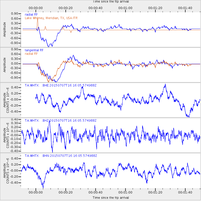
WHTX Lake Whitney, Meridian, TX, USA - Earthquake Result Viewer
*The percent match for this event was below the threshold and hence no stack was calculated.
| Earthquake location: |
Central East Pacific Rise |
| Earthquake latitude/longitude: |
-13.4/-111.3 |
| Earthquake time(UTC): |
2015/07/07 (188) 16:08:03 GMT |
| Earthquake Depth: |
10 km |
| Earthquake Magnitude: |
5.7 MWW, 5.7 MWC |
| Earthquake Catalog/Contributor: |
NEIC PDE/NEIC COMCAT |
|
| Network: |
TA USArray Transportable Network (new EarthScope stations) |
| Station: |
WHTX Lake Whitney, Meridian, TX, USA |
| Lat/Lon: |
31.99 N/97.46 W |
| Elevation: |
190 m |
|
| Distance: |
47.0 deg |
| Az: |
16.13 deg |
| Baz: |
198.553 deg |
| Ray Param: |
$rayparam |
*The percent match for this event was below the threshold and hence was not used in the summary stack. |
|
| Radial Match: |
52.356922 % |
| Radial Bump: |
400 |
| Transverse Match: |
52.64691 % |
| Transverse Bump: |
400 |
| SOD ConfigId: |
7422571 |
| Insert Time: |
2019-04-19 16:51:32.584 +0000 |
| GWidth: |
2.5 |
| Max Bumps: |
400 |
| Tol: |
0.001 |
|
Signal To Noise
| Channel | StoN | STA | LTA |
| TA:WHTX: :BHZ:20150707T16:16:05.574988Z | 1.2218987 | 1.015511E-7 | 8.310926E-8 |
| TA:WHTX: :BHN:20150707T16:16:05.574988Z | 3.0710711 | 2.6260668E-7 | 8.55098E-8 |
| TA:WHTX: :BHE:20150707T16:16:05.574988Z | 1.8937615 | 2.827917E-7 | 1.4932803E-7 |
| Arrivals |
| Ps | |
| PpPs | |
| PsPs/PpSs | |


