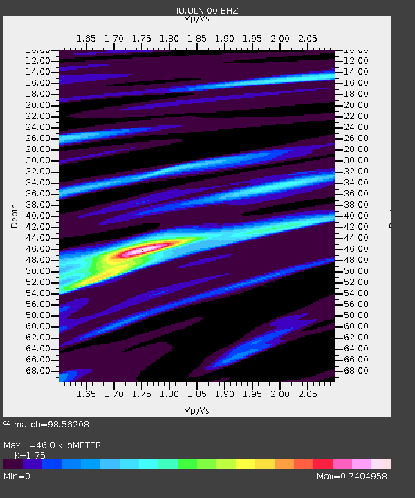
ULN Ulaanbaatar, Mongolia - Earthquake Result Viewer
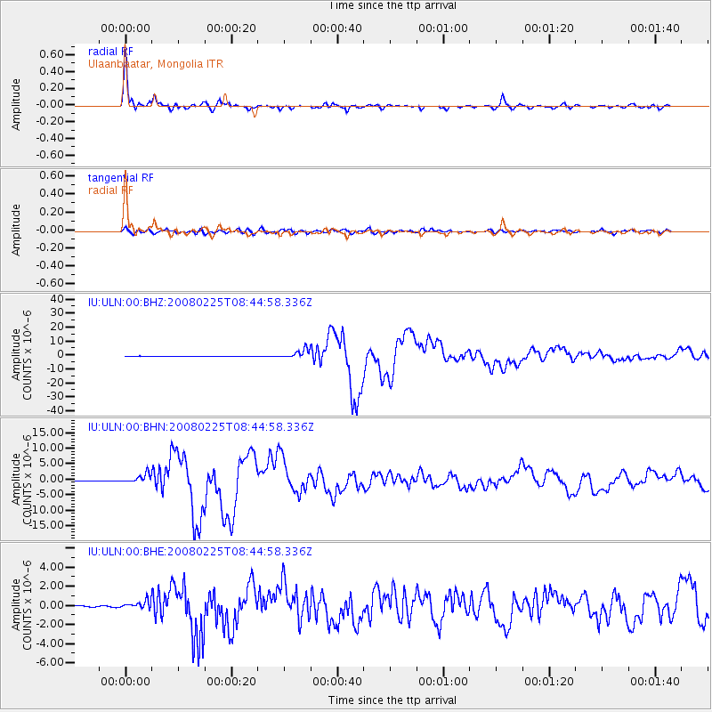
Earthquake location: Southern Sumatra, Indonesia
Earthquake latitude/longitude: -2.5/100.0
Earthquake time(UTC): 2008/02/25 (056) 08:36:33 GMT
Earthquake Depth: 25 km
Earthquake Magnitude: 6.4 MB, 7.3 MS, 7.0 MW, 6.9 MW
Earthquake Catalog/Contributor: WHDF/NEIC
Network: IU Global Seismograph Network (GSN - IRIS/USGS)
Station: ULN Ulaanbaatar, Mongolia
Lat/Lon: 47.87 N/107.05 E
Elevation: 1610 m
Distance: 50.5 deg
Az: 6.173 deg
Baz: 189.181 deg
Ray Param: 0.06795752
Estimated Moho Depth: 46.0 km
Estimated Crust Vp/Vs: 1.75
Assumed Crust Vp: 6.642 km/s
Estimated Crust Vs: 3.795 km/s
Estimated Crust Poisson's Ratio: 0.26
Radial Match: 98.56208 %
Radial Bump: 339
Transverse Match: 87.55583 %
Transverse Bump: 400
SOD ConfigId: 2564
Insert Time: 2010-03-03 16:00:40.154 +0000
GWidth: 2.5
Max Bumps: 400
Tol: 0.001

Signal To Noise

ChannelStoNSTALTA
IU:ULN:00:BHN:20080225T08:44:58.336Z17.512671.4764199E-68.430581E-8
IU:ULN:00:BHE:20080225T08:44:58.336Z9.3045974.370914E-74.6975853E-8
IU:ULN:00:BHZ:20080225T08:44:58.336Z27.4915083.153031E-61.1469108E-7
Arrivals
Ps5.5 SECOND
PpPs18 SECOND
PsPs/PpSs23 SECOND