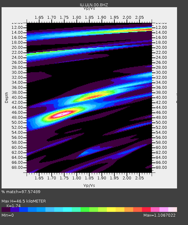
ULN Ulaanbaatar, Mongolia - Earthquake Result Viewer
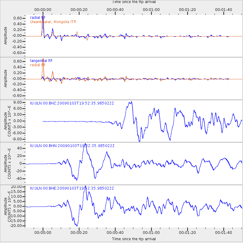
Earthquake location: Irian Jaya Region, Indonesia
Earthquake latitude/longitude: -0.4/132.9
Earthquake time(UTC): 2009/01/03 (003) 19:43:50 GMT
Earthquake Depth: 17 km
Earthquake Magnitude: 6.6 MB, 7.5 MS, 7.6 MW, 7.6 MW
Earthquake Catalog/Contributor: WHDF/NEIC
Network: IU Global Seismograph Network (GSN - IRIS/USGS)
Station: ULN Ulaanbaatar, Mongolia
Lat/Lon: 47.87 N/107.05 E
Elevation: 1610 m
Distance: 53.1 deg
Az: 338.469 deg
Baz: 146.973 deg
Ray Param: 0.06632474
Estimated Moho Depth: 46.5 km
Estimated Crust Vp/Vs: 1.74
Assumed Crust Vp: 6.642 km/s
Estimated Crust Vs: 3.817 km/s
Estimated Crust Poisson's Ratio: 0.25
Radial Match: 97.57489 %
Radial Bump: 399
Transverse Match: 90.54816 %
Transverse Bump: 400
SOD ConfigId: 2834
Insert Time: 2010-03-03 16:01:04.388 +0000
GWidth: 2.5
Max Bumps: 400
Tol: 0.001

Signal To Noise

ChannelStoNSTALTA
IU:ULN:00:BHN:20090103T19:52:35.985022Z6.4323968.396886E-71.3054056E-7
IU:ULN:00:BHE:20090103T19:52:35.985022Z5.7109934.7757084E-78.3623085E-8
IU:ULN:00:BHZ:20090103T19:52:35.985022Z4.3045123.0266696E-77.031389E-8
Arrivals
Ps5.5 SECOND
PpPs18 SECOND
PsPs/PpSs24 SECOND