You are here: Home > Network List > TA - USArray Transportable Network (new EarthScope stations) Stations List
> Station L04D Klamath Falls, OR, USA > Earthquake Result Viewer
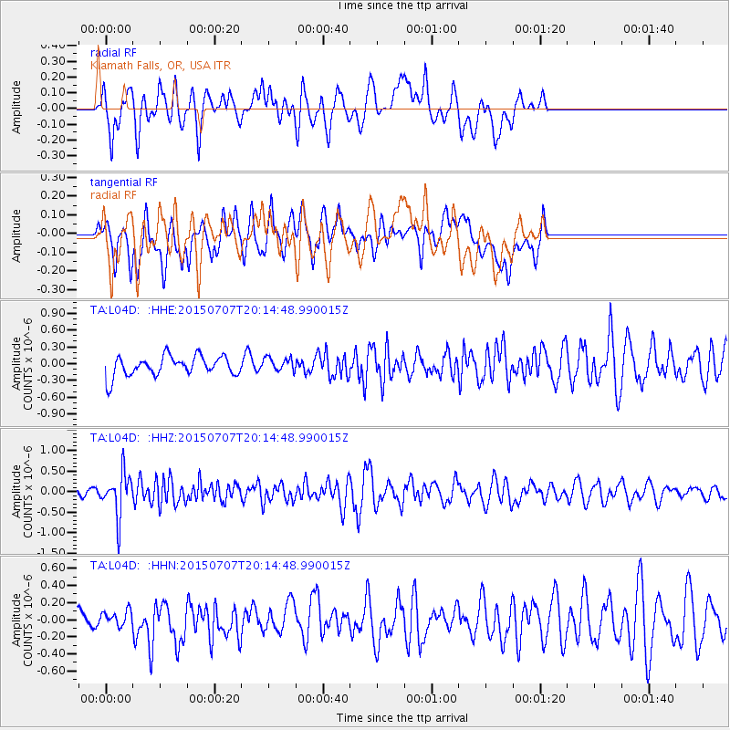
L04D Klamath Falls, OR, USA - Earthquake Result Viewer
*The percent match for this event was below the threshold and hence no stack was calculated.
| Earthquake location: |
South Of Fiji Islands |
| Earthquake latitude/longitude: |
-23.1/-177.0 |
| Earthquake time(UTC): |
2015/07/07 (188) 20:03:13 GMT |
| Earthquake Depth: |
120 km |
| Earthquake Magnitude: |
5.8 MO |
| Earthquake Catalog/Contributor: |
NEIC PDE/NEIC ALERT |
|
| Network: |
TA USArray Transportable Network (new EarthScope stations) |
| Station: |
L04D Klamath Falls, OR, USA |
| Lat/Lon: |
42.22 N/122.30 W |
| Elevation: |
1437 m |
|
| Distance: |
82.3 deg |
| Az: |
37.732 deg |
| Baz: |
229.342 deg |
| Ray Param: |
$rayparam |
*The percent match for this event was below the threshold and hence was not used in the summary stack. |
|
| Radial Match: |
62.189934 % |
| Radial Bump: |
400 |
| Transverse Match: |
68.397995 % |
| Transverse Bump: |
400 |
| SOD ConfigId: |
7422571 |
| Insert Time: |
2019-04-19 17:04:25.316 +0000 |
| GWidth: |
2.5 |
| Max Bumps: |
400 |
| Tol: |
0.001 |
|
Signal To Noise
| Channel | StoN | STA | LTA |
| TA:L04D: :HHZ:20150707T20:14:48.990015Z | 4.5599732 | 5.231832E-7 | 1.1473383E-7 |
| TA:L04D: :HHN:20150707T20:14:48.990015Z | 0.48913038 | 8.280875E-8 | 1.6929789E-7 |
| TA:L04D: :HHE:20150707T20:14:48.990015Z | 0.624084 | 9.2734425E-8 | 1.4859285E-7 |
| Arrivals |
| Ps | |
| PpPs | |
| PsPs/PpSs | |


