You are here: Home > Network List > TA - USArray Transportable Network (new EarthScope stations) Stations List
> Station N23A Red Feather Lakes, CO, USA > Earthquake Result Viewer
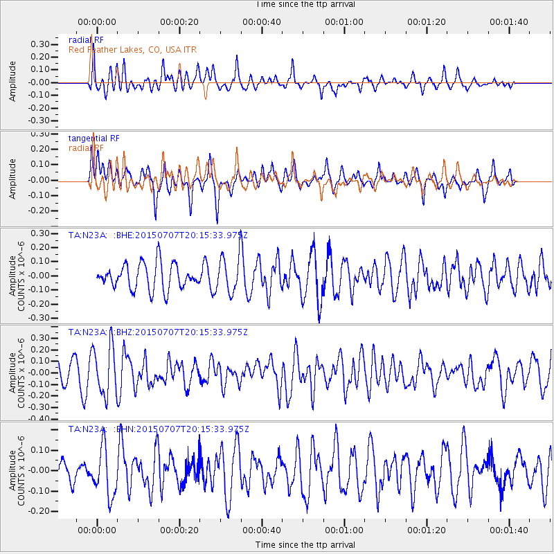
N23A Red Feather Lakes, CO, USA - Earthquake Result Viewer
*The percent match for this event was below the threshold and hence no stack was calculated.
| Earthquake location: |
South Of Fiji Islands |
| Earthquake latitude/longitude: |
-23.1/-177.0 |
| Earthquake time(UTC): |
2015/07/07 (188) 20:03:13 GMT |
| Earthquake Depth: |
120 km |
| Earthquake Magnitude: |
5.8 MO |
| Earthquake Catalog/Contributor: |
NEIC PDE/NEIC ALERT |
|
| Network: |
TA USArray Transportable Network (new EarthScope stations) |
| Station: |
N23A Red Feather Lakes, CO, USA |
| Lat/Lon: |
40.89 N/105.94 W |
| Elevation: |
2458 m |
|
| Distance: |
91.6 deg |
| Az: |
45.843 deg |
| Baz: |
240.63 deg |
| Ray Param: |
$rayparam |
*The percent match for this event was below the threshold and hence was not used in the summary stack. |
|
| Radial Match: |
52.12522 % |
| Radial Bump: |
400 |
| Transverse Match: |
60.745377 % |
| Transverse Bump: |
400 |
| SOD ConfigId: |
7422571 |
| Insert Time: |
2019-04-19 17:04:34.969 +0000 |
| GWidth: |
2.5 |
| Max Bumps: |
400 |
| Tol: |
0.001 |
|
Signal To Noise
| Channel | StoN | STA | LTA |
| TA:N23A: :BHZ:20150707T20:15:33.975Z | 2.415612 | 2.1541804E-7 | 8.917742E-8 |
| TA:N23A: :BHN:20150707T20:15:33.975Z | 2.5449884 | 1.2261346E-7 | 4.8178396E-8 |
| TA:N23A: :BHE:20150707T20:15:33.975Z | 1.6646656 | 1.5197628E-7 | 9.129538E-8 |
| Arrivals |
| Ps | |
| PpPs | |
| PsPs/PpSs | |


