You are here: Home > Network List > IU - Global Seismograph Network (GSN - IRIS/USGS) Stations List
> Station ULN Ulaanbaatar, Mongolia > Earthquake Result Viewer
ULN Ulaanbaatar, Mongolia - Earthquake Result Viewer
| Earthquake location: |
Cyprus Region |
| Earthquake latitude/longitude: |
34.6/32.1 |
| Earthquake time(UTC): |
1996/10/09 (283) 13:10:52 GMT |
| Earthquake Depth: |
33 km |
| Earthquake Magnitude: |
6.4 MB, 6.8 MS, 7.2 UNKNOWN, 6.8 MW |
| Earthquake Catalog/Contributor: |
WHDF/NEIC |
|
| Network: |
IU Global Seismograph Network (GSN - IRIS/USGS) |
| Station: |
ULN Ulaanbaatar, Mongolia |
| Lat/Lon: |
47.87 N/107.05 E |
| Elevation: |
1610 m |
|
| Distance: |
55.8 deg |
| Az: |
51.817 deg |
| Baz: |
285.533 deg |
| Ray Param: |
0.06449274 |
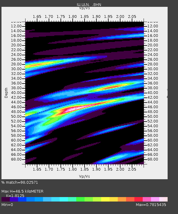
| Estimated Moho Depth: |
46.5 km |
| Estimated Crust Vp/Vs: |
1.81 |
| Assumed Crust Vp: |
6.642 km/s |
| Estimated Crust Vs: |
3.664 km/s |
| Estimated Crust Poisson's Ratio: |
0.28 |
|
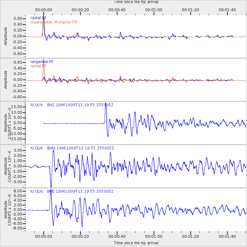
| Radial Match: |
98.02571 % |
| Radial Bump: |
201 |
| Transverse Match: |
92.255745 % |
| Transverse Bump: |
400 |
| SOD ConfigId: |
6273 |
| Insert Time: |
2010-03-03 16:02:54.235 +0000 |
| GWidth: |
2.5 |
| Max Bumps: |
400 |
| Tol: |
0.001 |
|
Signal To Noise
| Channel | StoN | STA | LTA |
| IU:ULN: :BHN:19961009T13:19:55.355005Z | 20.760092 | 1.3018584E-6 | 6.270967E-8 |
| IU:ULN: :BHE:19961009T13:19:55.355005Z | 53.50634 | 2.9548821E-6 | 5.52249E-8 |
| IU:ULN: :BHZ:19961009T13:19:55.355005Z | 86.05375 | 6.4176115E-6 | 7.457678E-8 |
| Arrivals |
| Ps | 6.0 SECOND |
| PpPs | 19 SECOND |
| PsPs/PpSs | 25 SECOND |


