You are here: Home > Network List > UW - Pacific Northwest Regional Seismic Network Stations List
> Station MRBL Marblemount, WA, USA > Earthquake Result Viewer
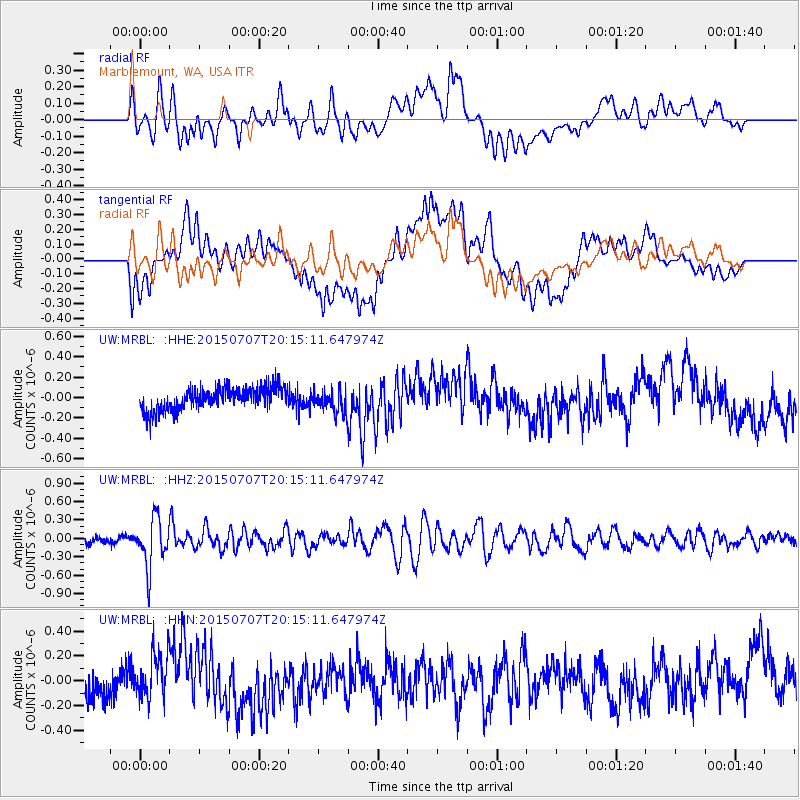
MRBL Marblemount, WA, USA - Earthquake Result Viewer
*The percent match for this event was below the threshold and hence no stack was calculated.
| Earthquake location: |
South Of Fiji Islands |
| Earthquake latitude/longitude: |
-23.1/-177.0 |
| Earthquake time(UTC): |
2015/07/07 (188) 20:03:13 GMT |
| Earthquake Depth: |
120 km |
| Earthquake Magnitude: |
5.8 MO |
| Earthquake Catalog/Contributor: |
NEIC PDE/NEIC ALERT |
|
| Network: |
UW Pacific Northwest Regional Seismic Network |
| Station: |
MRBL Marblemount, WA, USA |
| Lat/Lon: |
48.52 N/121.48 W |
| Elevation: |
75 m |
|
| Distance: |
86.8 deg |
| Az: |
33.304 deg |
| Baz: |
229.505 deg |
| Ray Param: |
$rayparam |
*The percent match for this event was below the threshold and hence was not used in the summary stack. |
|
| Radial Match: |
59.11506 % |
| Radial Bump: |
400 |
| Transverse Match: |
49.25062 % |
| Transverse Bump: |
400 |
| SOD ConfigId: |
7422571 |
| Insert Time: |
2019-04-19 17:05:38.356 +0000 |
| GWidth: |
2.5 |
| Max Bumps: |
400 |
| Tol: |
0.001 |
|
Signal To Noise
| Channel | StoN | STA | LTA |
| UW:MRBL: :HHZ:20150707T20:15:11.647974Z | 7.059355 | 3.93217E-7 | 5.570155E-8 |
| UW:MRBL: :HHN:20150707T20:15:11.647974Z | 1.0804484 | 1.8654981E-7 | 1.7265961E-7 |
| UW:MRBL: :HHE:20150707T20:15:11.647974Z | 1.4950572 | 1.5868478E-7 | 1.0613961E-7 |
| Arrivals |
| Ps | |
| PpPs | |
| PsPs/PpSs | |


