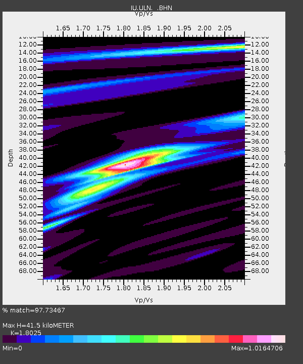
ULN Ulaanbaatar, Mongolia - Earthquake Result Viewer
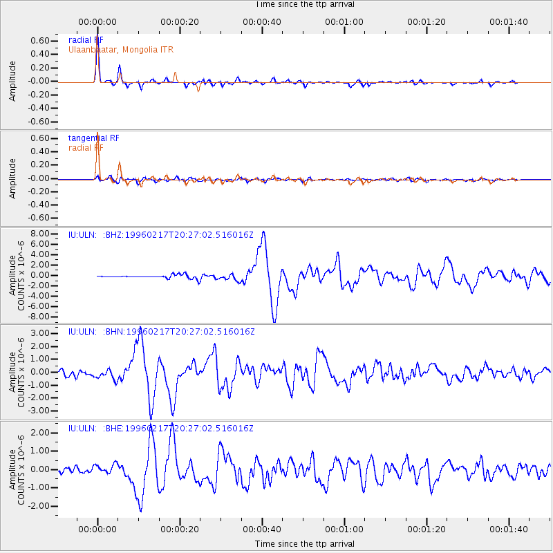
Earthquake location: Irian Jaya Region, Indonesia
Earthquake latitude/longitude: -0.9/136.1
Earthquake time(UTC): 1996/02/17 (048) 20:18:07 GMT
Earthquake Depth: 33 km
Earthquake Magnitude: 6.0 MB, 6.6 MS, 6.6 UNKNOWN
Earthquake Catalog/Contributor: WHDF/NEIC
Network: IU Global Seismograph Network (GSN - IRIS/USGS)
Station: ULN Ulaanbaatar, Mongolia
Lat/Lon: 47.87 N/107.05 E
Elevation: 1610 m
Distance: 54.7 deg
Az: 336.428 deg
Baz: 143.57 deg
Ray Param: 0.0652104
Estimated Moho Depth: 41.5 km
Estimated Crust Vp/Vs: 1.80
Assumed Crust Vp: 6.642 km/s
Estimated Crust Vs: 3.685 km/s
Estimated Crust Poisson's Ratio: 0.28
Radial Match: 97.73467 %
Radial Bump: 278
Transverse Match: 84.80185 %
Transverse Bump: 400
SOD ConfigId: 6273
Insert Time: 2010-03-03 16:03:29.176 +0000
GWidth: 2.5
Max Bumps: 400
Tol: 0.001

Signal To Noise

ChannelStoNSTALTA
IU:ULN: :BHN:19960217T20:27:02.516016Z2.1923113.7652893E-71.7174978E-7
IU:ULN: :BHE:19960217T20:27:02.516016Z2.923192.6625065E-79.108222E-8
IU:ULN: :BHZ:19960217T20:27:02.516016Z1.94994156.2806964E-73.2209664E-7
Arrivals
Ps5.3 SECOND
PpPs17 SECOND
PsPs/PpSs22 SECOND