You are here: Home > Network List > IU - Global Seismograph Network (GSN - IRIS/USGS) Stations List
> Station ULN Ulaanbaatar, Mongolia > Earthquake Result Viewer
ULN Ulaanbaatar, Mongolia - Earthquake Result Viewer
| Earthquake location: |
Mariana Islands |
| Earthquake latitude/longitude: |
14.0/144.9 |
| Earthquake time(UTC): |
1997/04/23 (113) 19:44:28 GMT |
| Earthquake Depth: |
101 km |
| Earthquake Magnitude: |
6.2 MB, 6.5 UNKNOWN, 6.5 MW |
| Earthquake Catalog/Contributor: |
WHDF/NEIC |
|
| Network: |
IU Global Seismograph Network (GSN - IRIS/USGS) |
| Station: |
ULN Ulaanbaatar, Mongolia |
| Lat/Lon: |
47.87 N/107.05 E |
| Elevation: |
1610 m |
|
| Distance: |
46.1 deg |
| Az: |
324.998 deg |
| Baz: |
124.215 deg |
| Ray Param: |
0.07053956 |
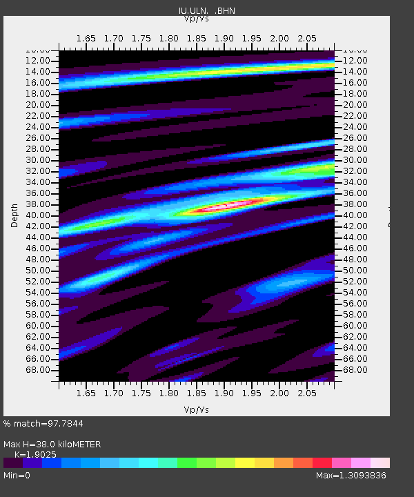
| Estimated Moho Depth: |
38.0 km |
| Estimated Crust Vp/Vs: |
1.90 |
| Assumed Crust Vp: |
6.642 km/s |
| Estimated Crust Vs: |
3.491 km/s |
| Estimated Crust Poisson's Ratio: |
0.31 |
|
| Radial Match: |
97.7844 % |
| Radial Bump: |
385 |
| Transverse Match: |
90.27871 % |
| Transverse Bump: |
400 |
| SOD ConfigId: |
6273 |
| Insert Time: |
2010-03-03 16:04:43.872 +0000 |
| GWidth: |
2.5 |
| Max Bumps: |
400 |
| Tol: |
0.001 |
|
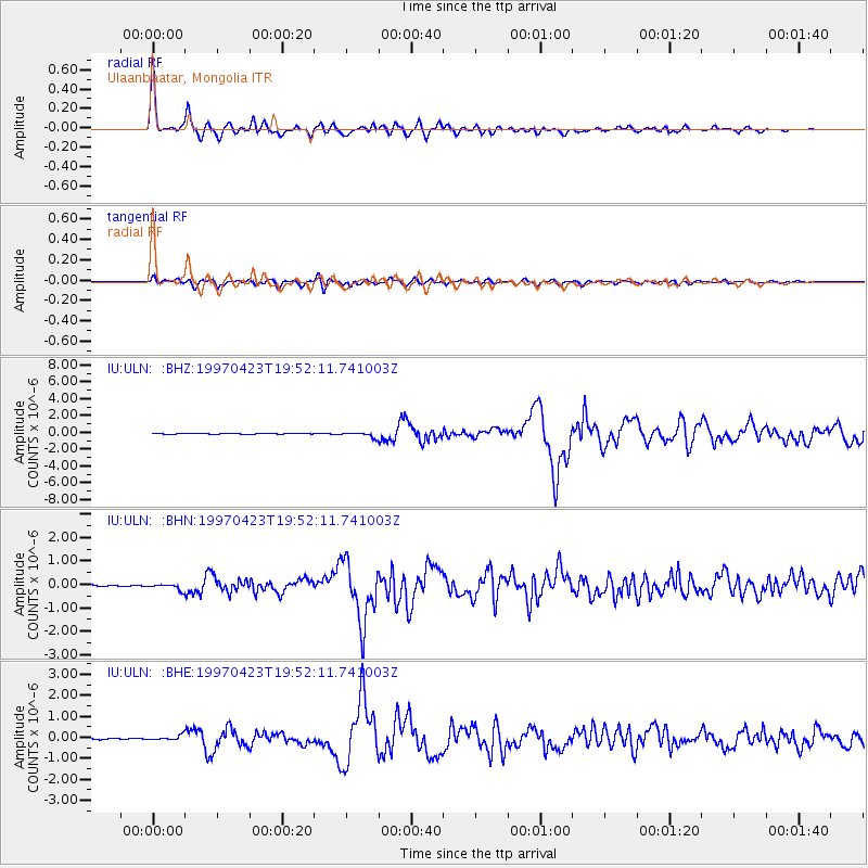
Signal To Noise
| Channel | StoN | STA | LTA |
| IU:ULN: :BHN:19970423T19:52:11.741003Z | 3.6595452 | 1.2881522E-7 | 3.5199786E-8 |
| IU:ULN: :BHE:19970423T19:52:11.741003Z | 2.8397198 | 1.1228882E-7 | 3.954222E-8 |
| IU:ULN: :BHZ:19970423T19:52:11.741003Z | 7.3883176 | 3.0370495E-7 | 4.11061E-8 |
| Arrivals |
| Ps | 5.5 SECOND |
| PpPs | 16 SECOND |
| PsPs/PpSs | 21 SECOND |


