You are here: Home > Network List > AV - Alaska Volcano Observatory Stations List
> Station MAPS Pakushin Southeast, Makushin Volcano, Alaska > Earthquake Result Viewer
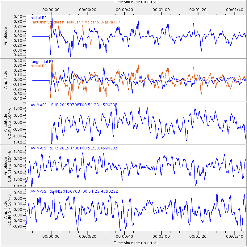
MAPS Pakushin Southeast, Makushin Volcano, Alaska - Earthquake Result Viewer
*The percent match for this event was below the threshold and hence no stack was calculated.
| Earthquake location: |
Northern Sumatra, Indonesia |
| Earthquake latitude/longitude: |
5.0/94.7 |
| Earthquake time(UTC): |
2015/07/08 (189) 00:38:56 GMT |
| Earthquake Depth: |
51 km |
| Earthquake Magnitude: |
5.0 MW |
| Earthquake Catalog/Contributor: |
ISC/ISC |
|
| Network: |
AV Alaska Volcano Observatory |
| Station: |
MAPS Pakushin Southeast, Makushin Volcano, Alaska |
| Lat/Lon: |
53.81 N/166.94 W |
| Elevation: |
333 m |
|
| Distance: |
90.9 deg |
| Az: |
35.936 deg |
| Baz: |
279.657 deg |
| Ray Param: |
$rayparam |
*The percent match for this event was below the threshold and hence was not used in the summary stack. |
|
| Radial Match: |
52.4113 % |
| Radial Bump: |
400 |
| Transverse Match: |
48.899147 % |
| Transverse Bump: |
400 |
| SOD ConfigId: |
7422571 |
| Insert Time: |
2019-04-19 17:16:26.916 +0000 |
| GWidth: |
2.5 |
| Max Bumps: |
400 |
| Tol: |
0.001 |
|
Signal To Noise
| Channel | StoN | STA | LTA |
| AV:MAPS: :BHZ:20150708T00:51:23.459023Z | 0.7401267 | 4.2884392E-7 | 5.794196E-7 |
| AV:MAPS: :BHN:20150708T00:51:23.459023Z | 1.0359885 | 4.4720164E-7 | 4.3166665E-7 |
| AV:MAPS: :BHE:20150708T00:51:23.459023Z | 1.0437294 | 5.4642237E-7 | 5.2352874E-7 |
| Arrivals |
| Ps | |
| PpPs | |
| PsPs/PpSs | |


