You are here: Home > Network List > IU - Global Seismograph Network (GSN - IRIS/USGS) Stations List
> Station ULN Ulaanbaatar, Mongolia > Earthquake Result Viewer
ULN Ulaanbaatar, Mongolia - Earthquake Result Viewer
| Earthquake location: |
Northern Molucca Sea |
| Earthquake latitude/longitude: |
1.1/126.3 |
| Earthquake time(UTC): |
2007/01/21 (021) 11:27:45 GMT |
| Earthquake Depth: |
22 km |
| Earthquake Magnitude: |
6.7 MB, 7.3 MS, 7.5 MW, 7.3 MW |
| Earthquake Catalog/Contributor: |
WHDF/NEIC |
|
| Network: |
IU Global Seismograph Network (GSN - IRIS/USGS) |
| Station: |
ULN Ulaanbaatar, Mongolia |
| Lat/Lon: |
47.87 N/107.05 E |
| Elevation: |
1610 m |
|
| Distance: |
49.5 deg |
| Az: |
343.046 deg |
| Baz: |
154.343 deg |
| Ray Param: |
0.06862459 |
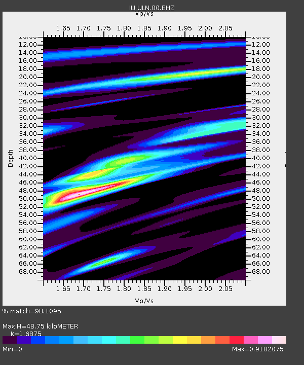
| Estimated Moho Depth: |
48.75 km |
| Estimated Crust Vp/Vs: |
1.69 |
| Assumed Crust Vp: |
6.642 km/s |
| Estimated Crust Vs: |
3.936 km/s |
| Estimated Crust Poisson's Ratio: |
0.23 |
|
| Radial Match: |
98.1095 % |
| Radial Bump: |
328 |
| Transverse Match: |
92.40936 % |
| Transverse Bump: |
400 |
| SOD ConfigId: |
2564 |
| Insert Time: |
2010-03-03 16:06:26.491 +0000 |
| GWidth: |
2.5 |
| Max Bumps: |
400 |
| Tol: |
0.001 |
|
Signal To Noise
| Channel | StoN | STA | LTA |
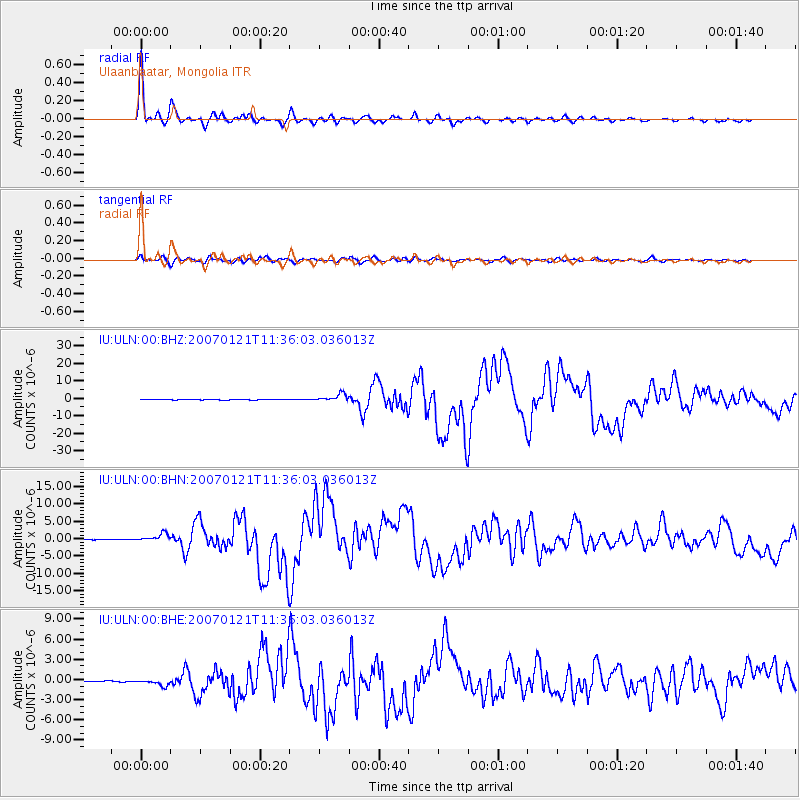
| IU:ULN:00:BHN:20070121T11:36:03.036013Z | 18.10024 | 1.1387294E-6 | 6.29124E-8 |
| IU:ULN:00:BHE:20070121T11:36:03.036013Z | 13.145949 | 4.7474342E-7 | 3.6113285E-8 |
| IU:ULN:00:BHZ:20070121T11:36:03.036013Z | 27.41831 | 2.2164425E-6 | 8.083804E-8 |
| Arrivals |
| Ps | 5.4 SECOND |
| PpPs | 18 SECOND |
| PsPs/PpSs | 24 SECOND |


