You are here: Home > Network List > CI - Caltech Regional Seismic Network Stations List
> Station MPM Manuel Prospect Mine, California, USA > Earthquake Result Viewer
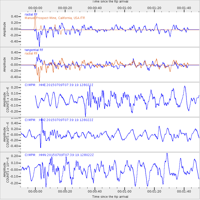
MPM Manuel Prospect Mine, California, USA - Earthquake Result Viewer
*The percent match for this event was below the threshold and hence no stack was calculated.
| Earthquake location: |
Fiji Islands Region |
| Earthquake latitude/longitude: |
-18.7/-177.1 |
| Earthquake time(UTC): |
2015/07/09 (190) 07:28:28 GMT |
| Earthquake Depth: |
352 km |
| Earthquake Magnitude: |
5.5 MW |
| Earthquake Catalog/Contributor: |
ISC/ISC |
|
| Network: |
CI Caltech Regional Seismic Network |
| Station: |
MPM Manuel Prospect Mine, California, USA |
| Lat/Lon: |
36.06 N/117.49 W |
| Elevation: |
185 m |
|
| Distance: |
78.4 deg |
| Az: |
45.547 deg |
| Baz: |
236.625 deg |
| Ray Param: |
$rayparam |
*The percent match for this event was below the threshold and hence was not used in the summary stack. |
|
| Radial Match: |
79.51914 % |
| Radial Bump: |
400 |
| Transverse Match: |
75.437485 % |
| Transverse Bump: |
400 |
| SOD ConfigId: |
7422571 |
| Insert Time: |
2019-04-19 17:25:41.425 +0000 |
| GWidth: |
2.5 |
| Max Bumps: |
400 |
| Tol: |
0.001 |
|
Signal To Noise
| Channel | StoN | STA | LTA |
| CI:MPM: :HHZ:20150709T07:39:19.128022Z | 2.1118295 | 2.2211957E-7 | 1.05178735E-7 |
| CI:MPM: :HHN:20150709T07:39:19.128022Z | 0.91949975 | 6.469256E-8 | 7.035625E-8 |
| CI:MPM: :HHE:20150709T07:39:19.128022Z | 1.2854347 | 9.3083756E-8 | 7.241422E-8 |
| Arrivals |
| Ps | |
| PpPs | |
| PsPs/PpSs | |


