You are here: Home > Network List > US - United States National Seismic Network Stations List
> Station EGMT Eagleton, Montana, USA > Earthquake Result Viewer
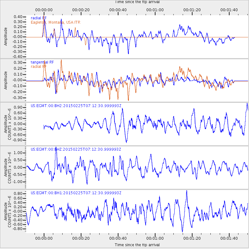
EGMT Eagleton, Montana, USA - Earthquake Result Viewer
*The percent match for this event was below the threshold and hence no stack was calculated.
| Earthquake location: |
Southeast Of Honshu, Japan |
| Earthquake latitude/longitude: |
31.1/141.9 |
| Earthquake time(UTC): |
2015/02/25 (056) 07:01:01 GMT |
| Earthquake Depth: |
10 km |
| Earthquake Magnitude: |
5.7 MB |
| Earthquake Catalog/Contributor: |
NEIC PDE/NEIC COMCAT |
|
| Network: |
US United States National Seismic Network |
| Station: |
EGMT Eagleton, Montana, USA |
| Lat/Lon: |
48.02 N/109.75 W |
| Elevation: |
1055 m |
|
| Distance: |
78.5 deg |
| Az: |
40.544 deg |
| Baz: |
303.825 deg |
| Ray Param: |
$rayparam |
*The percent match for this event was below the threshold and hence was not used in the summary stack. |
|
| Radial Match: |
62.518185 % |
| Radial Bump: |
400 |
| Transverse Match: |
55.427532 % |
| Transverse Bump: |
400 |
| SOD ConfigId: |
872571 |
| Insert Time: |
2015-03-11 07:20:36.319 +0000 |
| GWidth: |
2.5 |
| Max Bumps: |
400 |
| Tol: |
0.001 |
|
Signal To Noise
| Channel | StoN | STA | LTA |
| US:EGMT:00:BHZ:20150225T07:12:30.999993Z | 3.454111 | 3.7701588E-7 | 1.091499E-7 |
| US:EGMT:00:BH1:20150225T07:12:30.999993Z | 0.9752776 | 2.0740526E-7 | 2.1266281E-7 |
| US:EGMT:00:BH2:20150225T07:12:30.999993Z | 1.268592 | 2.1022274E-7 | 1.6571343E-7 |
| Arrivals |
| Ps | |
| PpPs | |
| PsPs/PpSs | |


