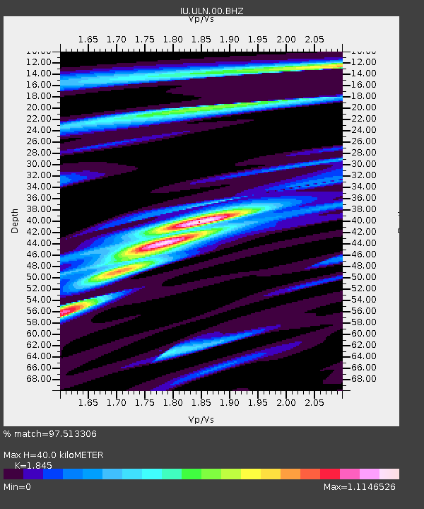
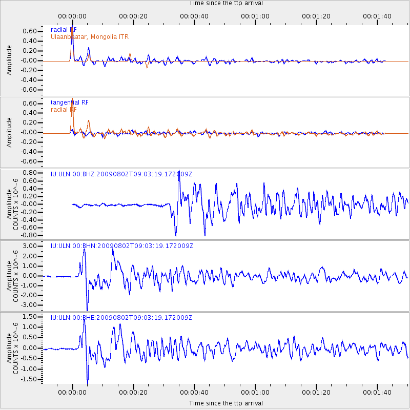
ULN Ulaanbaatar, Mongolia - Earthquake Result Viewer

Earthquake location: Irian Jaya Region, Indonesia
Earthquake latitude/longitude: -0.5/132.9
Earthquake time(UTC): 2009/08/02 (214) 08:54:35 GMT
Earthquake Depth: 35 km
Earthquake Magnitude: 5.8 MB, 5.8 MS, 6.1 MW, 6.0 MW
Earthquake Catalog/Contributor: WHDF/NEIC
Network: IU Global Seismograph Network (GSN - IRIS/USGS)
Station: ULN Ulaanbaatar, Mongolia
Lat/Lon: 47.87 N/107.05 E
Elevation: 1610 m
Distance: 53.1 deg
Az: 338.475 deg
Baz: 146.983 deg
Ray Param: 0.06623784
Estimated Moho Depth: 40.0 km
Estimated Crust Vp/Vs: 1.85
Assumed Crust Vp: 6.642 km/s
Estimated Crust Vs: 3.6 km/s
Estimated Crust Poisson's Ratio: 0.29
Radial Match: 97.513306 %
Radial Bump: 274
Transverse Match: 88.196976 %
Transverse Bump: 400
SOD ConfigId: 2622
Insert Time: 2010-03-03 16:07:02.867 +0000
GWidth: 2.5
Max Bumps: 400
Tol: 0.001

Signal To Noise

ChannelStoNSTALTA
IU:ULN:00:BHN:20090802T09:03:19.172009Z35.3159521.2295643E-63.4816118E-8
IU:ULN:00:BHE:20090802T09:03:19.172009Z20.9701885.540974E-72.6423104E-8
IU:ULN:00:BHZ:20090802T09:03:19.172009Z14.1987552.9456314E-72.0745702E-8
Arrivals
Ps5.4 SECOND
PpPs16 SECOND
PsPs/PpSs22 SECOND