You are here: Home > Network List > TA - USArray Transportable Network (new EarthScope stations) Stations List
> Station L04D Klamath Falls, OR, USA > Earthquake Result Viewer
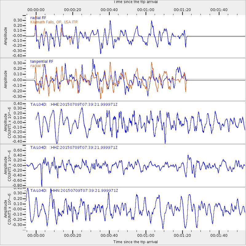
L04D Klamath Falls, OR, USA - Earthquake Result Viewer
*The percent match for this event was below the threshold and hence no stack was calculated.
| Earthquake location: |
Fiji Islands Region |
| Earthquake latitude/longitude: |
-18.7/-177.1 |
| Earthquake time(UTC): |
2015/07/09 (190) 07:28:28 GMT |
| Earthquake Depth: |
352 km |
| Earthquake Magnitude: |
5.5 MW |
| Earthquake Catalog/Contributor: |
ISC/ISC |
|
| Network: |
TA USArray Transportable Network (new EarthScope stations) |
| Station: |
L04D Klamath Falls, OR, USA |
| Lat/Lon: |
42.22 N/122.30 W |
| Elevation: |
1437 m |
|
| Distance: |
78.9 deg |
| Az: |
38.224 deg |
| Baz: |
232.147 deg |
| Ray Param: |
$rayparam |
*The percent match for this event was below the threshold and hence was not used in the summary stack. |
|
| Radial Match: |
52.10849 % |
| Radial Bump: |
400 |
| Transverse Match: |
57.288933 % |
| Transverse Bump: |
355 |
| SOD ConfigId: |
7422571 |
| Insert Time: |
2019-04-19 17:28:46.663 +0000 |
| GWidth: |
2.5 |
| Max Bumps: |
400 |
| Tol: |
0.001 |
|
Signal To Noise
| Channel | StoN | STA | LTA |
| TA:L04D: :HHZ:20150709T07:39:21.999971Z | 2.7063315 | 2.2989707E-7 | 8.494786E-8 |
| TA:L04D: :HHN:20150709T07:39:21.999971Z | 0.9785958 | 1.0862979E-7 | 1.1100578E-7 |
| TA:L04D: :HHE:20150709T07:39:21.999971Z | 0.6202049 | 1.06402304E-7 | 1.7155992E-7 |
| Arrivals |
| Ps | |
| PpPs | |
| PsPs/PpSs | |


