You are here: Home > Network List > UW - Pacific Northwest Regional Seismic Network Stations List
> Station UMAT Pilot Rock, OR, USA > Earthquake Result Viewer
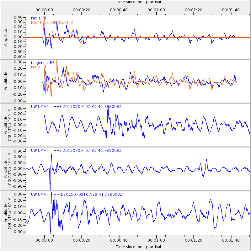
UMAT Pilot Rock, OR, USA - Earthquake Result Viewer
*The percent match for this event was below the threshold and hence no stack was calculated.
| Earthquake location: |
Fiji Islands Region |
| Earthquake latitude/longitude: |
-18.7/-177.1 |
| Earthquake time(UTC): |
2015/07/09 (190) 07:28:28 GMT |
| Earthquake Depth: |
352 km |
| Earthquake Magnitude: |
5.5 MW |
| Earthquake Catalog/Contributor: |
ISC/ISC |
|
| Network: |
UW Pacific Northwest Regional Seismic Network |
| Station: |
UMAT Pilot Rock, OR, USA |
| Lat/Lon: |
45.29 N/118.96 W |
| Elevation: |
1318 m |
|
| Distance: |
82.7 deg |
| Az: |
37.203 deg |
| Baz: |
234.29 deg |
| Ray Param: |
$rayparam |
*The percent match for this event was below the threshold and hence was not used in the summary stack. |
|
| Radial Match: |
72.13498 % |
| Radial Bump: |
400 |
| Transverse Match: |
61.949158 % |
| Transverse Bump: |
400 |
| SOD ConfigId: |
7422571 |
| Insert Time: |
2019-04-19 17:30:15.569 +0000 |
| GWidth: |
2.5 |
| Max Bumps: |
400 |
| Tol: |
0.001 |
|
Signal To Noise
| Channel | StoN | STA | LTA |
| UW:UMAT: :HHZ:20150709T07:39:41.738008Z | 4.0694447 | 3.1109462E-7 | 7.644646E-8 |
| UW:UMAT: :HHN:20150709T07:39:41.738008Z | 1.9291341 | 1.3015848E-7 | 6.74699E-8 |
| UW:UMAT: :HHE:20150709T07:39:41.738008Z | 1.560453 | 1.4822646E-7 | 9.4989375E-8 |
| Arrivals |
| Ps | |
| PpPs | |
| PsPs/PpSs | |


