You are here: Home > Network List > G - GEOSCOPE Stations List
> Station CRZF Port Alfred, Crozet, South Indian Ocean > Earthquake Result Viewer
CRZF Port Alfred, Crozet, South Indian Ocean - Earthquake Result Viewer
| Earthquake location: |
Flores Sea |
| Earthquake latitude/longitude: |
-7.3/122.5 |
| Earthquake time(UTC): |
2015/02/27 (058) 13:45:05 GMT |
| Earthquake Depth: |
547 km |
| Earthquake Magnitude: |
6.6 MB |
| Earthquake Catalog/Contributor: |
NEIC PDE/NEIC ALERT |
|
| Network: |
G GEOSCOPE |
| Station: |
CRZF Port Alfred, Crozet, South Indian Ocean |
| Lat/Lon: |
46.43 S/51.86 E |
| Elevation: |
140 m |
|
| Distance: |
71.4 deg |
| Az: |
223.503 deg |
| Baz: |
80.876 deg |
| Ray Param: |
0.05250086 |
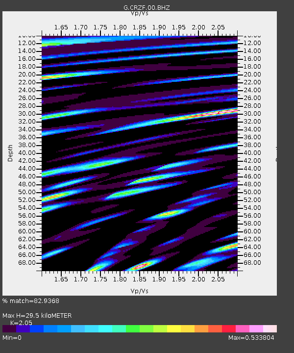
| Estimated Moho Depth: |
29.5 km |
| Estimated Crust Vp/Vs: |
2.05 |
| Assumed Crust Vp: |
4.802 km/s |
| Estimated Crust Vs: |
2.342 km/s |
| Estimated Crust Poisson's Ratio: |
0.34 |
|
| Radial Match: |
82.9368 % |
| Radial Bump: |
400 |
| Transverse Match: |
56.062004 % |
| Transverse Bump: |
400 |
| SOD ConfigId: |
872571 |
| Insert Time: |
2015-03-13 13:53:42.459 +0000 |
| GWidth: |
2.5 |
| Max Bumps: |
400 |
| Tol: |
0.001 |
|
Signal To Noise
| Channel | StoN | STA | LTA |
| G:CRZF:00:BHZ:20150227T13:54:59.250Z | 9.027418 | 5.1500433E-6 | 5.704891E-7 |
| G:CRZF:00:BHN:20150227T13:54:59.250Z | 0.8221549 | 4.723509E-7 | 5.745279E-7 |
| G:CRZF:00:BHE:20150227T13:54:59.250Z | 4.7266884 | 2.0186421E-6 | 4.2707327E-7 |
| Arrivals |
| Ps | 6.6 SECOND |
| PpPs | 18 SECOND |
| PsPs/PpSs | 25 SECOND |


