You are here: Home > Network List > TA - USArray Transportable Network (new EarthScope stations) Stations List
> Station J05D Fort Rock, OR, USA > Earthquake Result Viewer
J05D Fort Rock, OR, USA - Earthquake Result Viewer
*The percent match for this event was below the threshold and hence no stack was calculated.
| Earthquake location: |
Near East Coast Of Honshu, Japan |
| Earthquake latitude/longitude: |
40.1/142.6 |
| Earthquake time(UTC): |
2015/07/09 (190) 08:27:38 GMT |
| Earthquake Depth: |
36 km |
| Earthquake Magnitude: |
5.3 MW |
| Earthquake Catalog/Contributor: |
ISC/ISC |
|
| Network: |
TA USArray Transportable Network (new EarthScope stations) |
| Station: |
J05D Fort Rock, OR, USA |
| Lat/Lon: |
43.28 N/121.23 W |
| Elevation: |
1541 m |
|
| Distance: |
67.8 deg |
| Az: |
51.643 deg |
| Baz: |
304.565 deg |
| Ray Param: |
$rayparam |
*The percent match for this event was below the threshold and hence was not used in the summary stack. |
|
| Radial Match: |
43.611958 % |
| Radial Bump: |
387 |
| Transverse Match: |
43.44898 % |
| Transverse Bump: |
400 |
| SOD ConfigId: |
7422571 |
| Insert Time: |
2019-04-19 17:38:10.722 +0000 |
| GWidth: |
2.5 |
| Max Bumps: |
400 |
| Tol: |
0.001 |
|
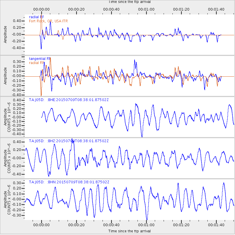
Signal To Noise
| Channel | StoN | STA | LTA |
| TA:J05D: :BHZ:20150709T08:38:01.87502Z | 1.9454827 | 2.2440086E-7 | 1.1534456E-7 |
| TA:J05D: :BHN:20150709T08:38:01.87502Z | 0.41152245 | 6.722042E-8 | 1.6334569E-7 |
| TA:J05D: :BHE:20150709T08:38:01.87502Z | 1.757161 | 1.848328E-7 | 1.0518831E-7 |
| Arrivals |
| Ps | |
| PpPs | |
| PsPs/PpSs | |


