You are here: Home > Network List > II - Global Seismograph Network (GSN - IRIS/IDA) Stations List
> Station ABPO Ambohimpanompo, Madagascar > Earthquake Result Viewer
ABPO Ambohimpanompo, Madagascar - Earthquake Result Viewer
| Earthquake location: |
Flores Sea |
| Earthquake latitude/longitude: |
-7.3/122.5 |
| Earthquake time(UTC): |
2015/02/27 (058) 13:45:05 GMT |
| Earthquake Depth: |
547 km |
| Earthquake Magnitude: |
6.6 MB |
| Earthquake Catalog/Contributor: |
NEIC PDE/NEIC ALERT |
|
| Network: |
II Global Seismograph Network (GSN - IRIS/IDA) |
| Station: |
ABPO Ambohimpanompo, Madagascar |
| Lat/Lon: |
19.02 S/47.23 E |
| Elevation: |
1528 m |
|
| Distance: |
73.8 deg |
| Az: |
252.355 deg |
| Baz: |
92.237 deg |
| Ray Param: |
0.050998744 |
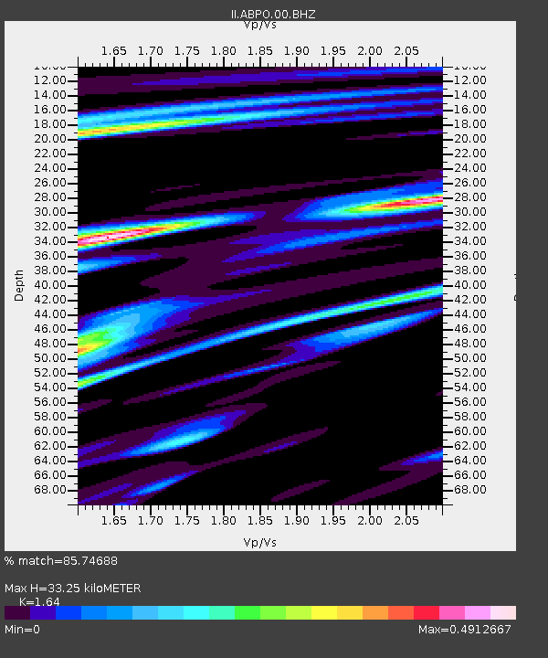
| Estimated Moho Depth: |
33.25 km |
| Estimated Crust Vp/Vs: |
1.64 |
| Assumed Crust Vp: |
6.642 km/s |
| Estimated Crust Vs: |
4.05 km/s |
| Estimated Crust Poisson's Ratio: |
0.20 |
|
| Radial Match: |
85.74688 % |
| Radial Bump: |
400 |
| Transverse Match: |
70.0316 % |
| Transverse Bump: |
331 |
| SOD ConfigId: |
872571 |
| Insert Time: |
2015-03-13 13:54:41.428 +0000 |
| GWidth: |
2.5 |
| Max Bumps: |
400 |
| Tol: |
0.001 |
|

Signal To Noise
| Channel | StoN | STA | LTA |
| II:ABPO:00:BHZ:20150227T13:55:12.718994Z | 3.4238713 | 5.1980855E-6 | 1.5181895E-6 |
| II:ABPO:00:BH1:20150227T13:55:12.718994Z | 1.2612967 | 1.3860498E-6 | 1.0989086E-6 |
| II:ABPO:00:BH2:20150227T13:55:12.718994Z | 5.7783885 | 2.6722219E-6 | 4.6245103E-7 |
| Arrivals |
| Ps | 3.3 SECOND |
| PpPs | 13 SECOND |
| PsPs/PpSs | 16 SECOND |


