You are here: Home > Network List > UW - Pacific Northwest Regional Seismic Network Stations List
> Station LEBA Lebam, WA, USA > Earthquake Result Viewer
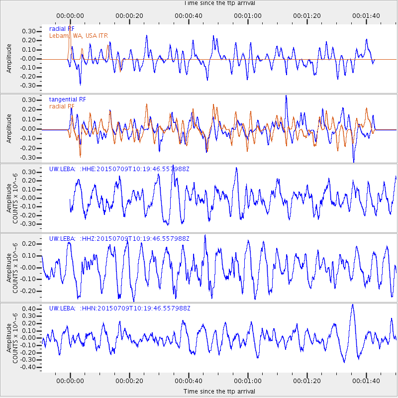
LEBA Lebam, WA, USA - Earthquake Result Viewer
*The percent match for this event was below the threshold and hence no stack was calculated.
| Earthquake location: |
New Ireland Region, P.N.G. |
| Earthquake latitude/longitude: |
-4.3/153.5 |
| Earthquake time(UTC): |
2015/07/09 (190) 10:07:38 GMT |
| Earthquake Depth: |
107 km |
| Earthquake Magnitude: |
5.2 MW |
| Earthquake Catalog/Contributor: |
ISC/ISC |
|
| Network: |
UW Pacific Northwest Regional Seismic Network |
| Station: |
LEBA Lebam, WA, USA |
| Lat/Lon: |
46.55 N/123.56 W |
| Elevation: |
73 m |
|
| Distance: |
88.3 deg |
| Az: |
43.262 deg |
| Baz: |
261.959 deg |
| Ray Param: |
$rayparam |
*The percent match for this event was below the threshold and hence was not used in the summary stack. |
|
| Radial Match: |
43.98735 % |
| Radial Bump: |
400 |
| Transverse Match: |
55.410248 % |
| Transverse Bump: |
400 |
| SOD ConfigId: |
7422571 |
| Insert Time: |
2019-04-19 17:44:15.507 +0000 |
| GWidth: |
2.5 |
| Max Bumps: |
400 |
| Tol: |
0.001 |
|
Signal To Noise
| Channel | StoN | STA | LTA |
| UW:LEBA: :HHZ:20150709T10:19:46.557988Z | 1.6965299 | 1.6005556E-7 | 9.434291E-8 |
| UW:LEBA: :HHN:20150709T10:19:46.557988Z | 0.85331917 | 6.711063E-8 | 7.864658E-8 |
| UW:LEBA: :HHE:20150709T10:19:46.557988Z | 2.038324 | 2.3309023E-7 | 1.1435386E-7 |
| Arrivals |
| Ps | |
| PpPs | |
| PsPs/PpSs | |


