You are here: Home > Network List > ND - New CaleDonia Broadband Seismic Network Stations List
> Station MARNC Mare, Loyalty islands, New Caledonia > Earthquake Result Viewer
MARNC Mare, Loyalty islands, New Caledonia - Earthquake Result Viewer
| Earthquake location: |
Flores Sea |
| Earthquake latitude/longitude: |
-7.3/122.5 |
| Earthquake time(UTC): |
2015/02/27 (058) 13:45:05 GMT |
| Earthquake Depth: |
547 km |
| Earthquake Magnitude: |
6.6 MB |
| Earthquake Catalog/Contributor: |
NEIC PDE/NEIC ALERT |
|
| Network: |
ND New CaleDonia Broadband Seismic Network |
| Station: |
MARNC Mare, Loyalty islands, New Caledonia |
| Lat/Lon: |
21.48 S/168.03 E |
| Elevation: |
44 m |
|
| Distance: |
46.1 deg |
| Az: |
112.774 deg |
| Baz: |
280.858 deg |
| Ray Param: |
0.068238765 |
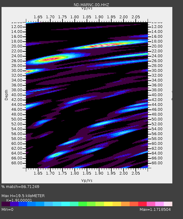
| Estimated Moho Depth: |
19.5 km |
| Estimated Crust Vp/Vs: |
1.91 |
| Assumed Crust Vp: |
4.082 km/s |
| Estimated Crust Vs: |
2.137 km/s |
| Estimated Crust Poisson's Ratio: |
0.31 |
|
| Radial Match: |
86.71249 % |
| Radial Bump: |
400 |
| Transverse Match: |
75.41543 % |
| Transverse Bump: |
400 |
| SOD ConfigId: |
872571 |
| Insert Time: |
2015-03-13 13:56:40.398 +0000 |
| GWidth: |
2.5 |
| Max Bumps: |
400 |
| Tol: |
0.001 |
|
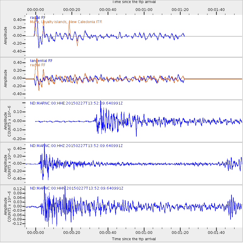
Signal To Noise
| Channel | StoN | STA | LTA |
| ND:MARNC:00:HHZ:20150227T13:52:09.640991Z | 48.08742 | 1.2591964E-7 | 2.6185567E-9 |
| ND:MARNC:00:HHN:20150227T13:52:09.640991Z | 8.089131 | 2.1901668E-8 | 2.7075426E-9 |
| ND:MARNC:00:HHE:20150227T13:52:09.640991Z | 11.440532 | 3.7113963E-8 | 3.2440768E-9 |
| Arrivals |
| Ps | 4.4 SECOND |
| PpPs | 14 SECOND |
| PsPs/PpSs | 18 SECOND |


