You are here: Home > Network List > TA - USArray Transportable Network (new EarthScope stations) Stations List
> Station MDND Maddock, ND, USA > Earthquake Result Viewer
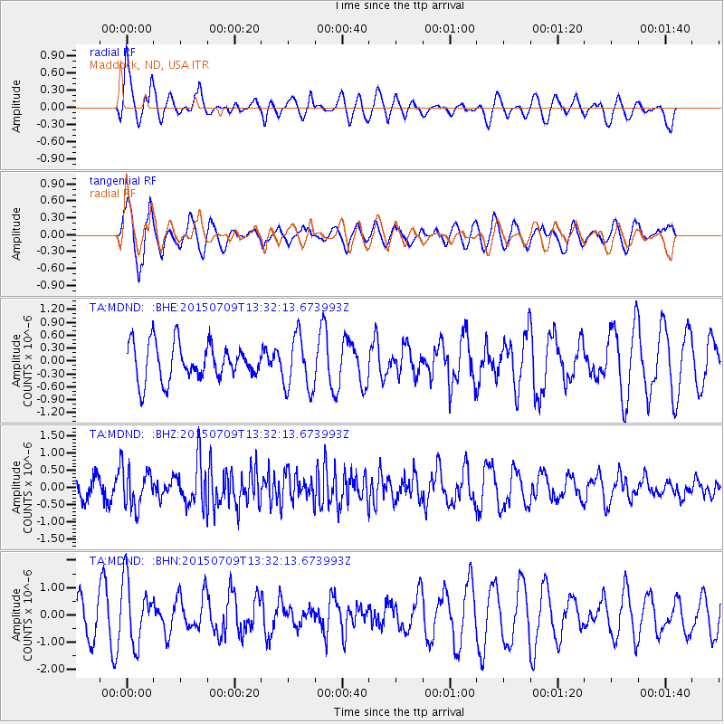
MDND Maddock, ND, USA - Earthquake Result Viewer
*The percent match for this event was below the threshold and hence no stack was calculated.
| Earthquake location: |
Near Coast Of Guatemala |
| Earthquake latitude/longitude: |
13.3/-90.2 |
| Earthquake time(UTC): |
2015/07/09 (190) 13:25:54 GMT |
| Earthquake Depth: |
48 km |
| Earthquake Magnitude: |
5.6 MWW, 5.6 MWC |
| Earthquake Catalog/Contributor: |
NEIC PDE/NEIC COMCAT |
|
| Network: |
TA USArray Transportable Network (new EarthScope stations) |
| Station: |
MDND Maddock, ND, USA |
| Lat/Lon: |
47.85 N/99.60 W |
| Elevation: |
479 m |
|
| Distance: |
35.3 deg |
| Az: |
349.084 deg |
| Baz: |
164.115 deg |
| Ray Param: |
$rayparam |
*The percent match for this event was below the threshold and hence was not used in the summary stack. |
|
| Radial Match: |
74.9403 % |
| Radial Bump: |
400 |
| Transverse Match: |
82.105934 % |
| Transverse Bump: |
400 |
| SOD ConfigId: |
7422571 |
| Insert Time: |
2019-04-19 17:49:59.907 +0000 |
| GWidth: |
2.5 |
| Max Bumps: |
400 |
| Tol: |
0.001 |
|
Signal To Noise
| Channel | StoN | STA | LTA |
| TA:MDND: :BHZ:20150709T13:32:13.673993Z | 2.3326523 | 5.4658557E-7 | 2.3431934E-7 |
| TA:MDND: :BHN:20150709T13:32:13.673993Z | 2.0553863 | 1.1562627E-6 | 5.625525E-7 |
| TA:MDND: :BHE:20150709T13:32:13.673993Z | 1.4663131 | 6.0533745E-7 | 4.128296E-7 |
| Arrivals |
| Ps | |
| PpPs | |
| PsPs/PpSs | |


