You are here: Home > Network List > IU - Global Seismograph Network (GSN - IRIS/USGS) Stations List
> Station ULN Ulaanbaatar, Mongolia > Earthquake Result Viewer
ULN Ulaanbaatar, Mongolia - Earthquake Result Viewer
| Earthquake location: |
South Of Java, Indonesia |
| Earthquake latitude/longitude: |
-9.3/107.4 |
| Earthquake time(UTC): |
2006/07/17 (198) 08:19:28 GMT |
| Earthquake Depth: |
34 km |
| Earthquake Magnitude: |
6.1 MB, 7.2 MS, 7.7 MW, 7.2 MW |
| Earthquake Catalog/Contributor: |
WHDF/NEIC |
|
| Network: |
IU Global Seismograph Network (GSN - IRIS/USGS) |
| Station: |
ULN Ulaanbaatar, Mongolia |
| Lat/Lon: |
47.87 N/107.05 E |
| Elevation: |
1610 m |
|
| Distance: |
56.9 deg |
| Az: |
359.712 deg |
| Baz: |
179.578 deg |
| Ray Param: |
0.063798696 |
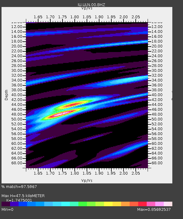
| Estimated Moho Depth: |
47.5 km |
| Estimated Crust Vp/Vs: |
1.75 |
| Assumed Crust Vp: |
6.642 km/s |
| Estimated Crust Vs: |
3.801 km/s |
| Estimated Crust Poisson's Ratio: |
0.26 |
|
| Radial Match: |
97.5967 % |
| Radial Bump: |
222 |
| Transverse Match: |
81.54479 % |
| Transverse Bump: |
400 |
| SOD ConfigId: |
2665 |
| Insert Time: |
2010-03-03 16:12:19.320 +0000 |
| GWidth: |
2.5 |
| Max Bumps: |
400 |
| Tol: |
0.001 |
|
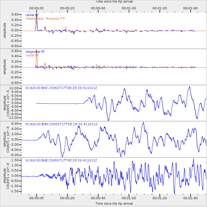
Signal To Noise
| Channel | StoN | STA | LTA |
| IU:ULN:00:BHN:20060717T08:28:39.411011Z | 23.036093 | 1.2283059E-6 | 5.332093E-8 |
| IU:ULN:00:BHE:20060717T08:28:39.411011Z | 3.5767167 | 8.4410075E-8 | 2.3599878E-8 |
| IU:ULN:00:BHZ:20060717T08:28:39.411011Z | 37.322525 | 2.644455E-6 | 7.085413E-8 |
| Arrivals |
| Ps | 5.6 SECOND |
| PpPs | 19 SECOND |
| PsPs/PpSs | 24 SECOND |


