You are here: Home > Network List > US - United States National Seismic Network Stations List
> Station ELK Elko, Nevada, USA > Earthquake Result Viewer
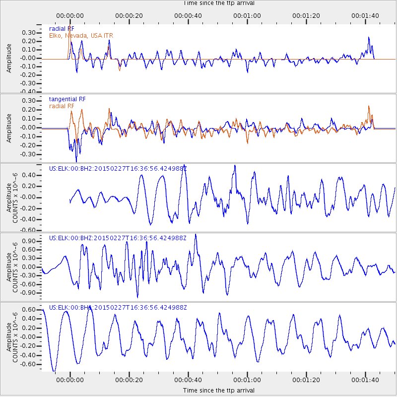
ELK Elko, Nevada, USA - Earthquake Result Viewer
*The percent match for this event was below the threshold and hence no stack was calculated.
| Earthquake location: |
Mariana Islands |
| Earthquake latitude/longitude: |
16.9/145.8 |
| Earthquake time(UTC): |
2015/02/27 (058) 16:24:50 GMT |
| Earthquake Depth: |
20 km |
| Earthquake Magnitude: |
5.7 MB |
| Earthquake Catalog/Contributor: |
NEIC PDE/NEIC ALERT |
|
| Network: |
US United States National Seismic Network |
| Station: |
ELK Elko, Nevada, USA |
| Lat/Lon: |
40.74 N/115.24 W |
| Elevation: |
2210 m |
|
| Distance: |
85.7 deg |
| Az: |
48.827 deg |
| Baz: |
288.492 deg |
| Ray Param: |
$rayparam |
*The percent match for this event was below the threshold and hence was not used in the summary stack. |
|
| Radial Match: |
55.770058 % |
| Radial Bump: |
374 |
| Transverse Match: |
78.1865 % |
| Transverse Bump: |
361 |
| SOD ConfigId: |
872571 |
| Insert Time: |
2015-03-13 16:42:57.056 +0000 |
| GWidth: |
2.5 |
| Max Bumps: |
400 |
| Tol: |
0.001 |
|
Signal To Noise
| Channel | StoN | STA | LTA |
| US:ELK:00:BHZ:20150227T16:36:56.424988Z | 2.874889 | 4.977058E-7 | 1.7312175E-7 |
| US:ELK:00:BH1:20150227T16:36:56.424988Z | 1.2787014 | 3.9474483E-7 | 3.0870757E-7 |
| US:ELK:00:BH2:20150227T16:36:56.424988Z | 2.4550655 | 3.1805098E-7 | 1.2954888E-7 |
| Arrivals |
| Ps | |
| PpPs | |
| PsPs/PpSs | |


