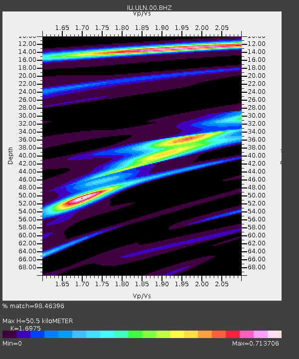
ULN Ulaanbaatar, Mongolia - Earthquake Result Viewer
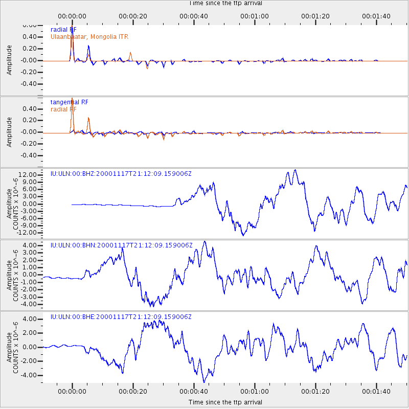
Earthquake location: New Britain Region, P.N.G.
Earthquake latitude/longitude: -5.5/151.8
Earthquake time(UTC): 2000/11/17 (322) 21:01:56 GMT
Earthquake Depth: 33 km
Earthquake Magnitude: 6.2 MB, 8.0 MS, 7.6 MW, 6.9 ME
Earthquake Catalog/Contributor: WHDF/NEIC
Network: IU Global Seismograph Network (GSN - IRIS/USGS)
Station: ULN Ulaanbaatar, Mongolia
Lat/Lon: 47.87 N/107.05 E
Elevation: 1610 m
Distance: 66.1 deg
Az: 328.769 deg
Baz: 129.957 deg
Ray Param: 0.05781543
Estimated Moho Depth: 50.5 km
Estimated Crust Vp/Vs: 1.70
Assumed Crust Vp: 6.642 km/s
Estimated Crust Vs: 3.913 km/s
Estimated Crust Poisson's Ratio: 0.23
Radial Match: 98.46396 %
Radial Bump: 213
Transverse Match: 87.35631 %
Transverse Bump: 400
SOD ConfigId: 3744
Insert Time: 2010-03-03 16:14:44.924 +0000
GWidth: 2.5
Max Bumps: 400
Tol: 0.001

Signal To Noise

ChannelStoNSTALTA
IU:ULN:00:BHN:20001117T21:12:09.159006Z3.41874743.6142046E-71.0571722E-7
IU:ULN:00:BHE:20001117T21:12:09.159006Z2.41528773.1145586E-71.2895187E-7
IU:ULN:00:BHZ:20001117T21:12:09.159006Z4.6967649.97877E-72.1246055E-7
Arrivals
Ps5.6 SECOND
PpPs20 SECOND
PsPs/PpSs25 SECOND