You are here: Home > Network List > IU - Global Seismograph Network (GSN - IRIS/USGS) Stations List
> Station ULN Ulaanbaatar, Mongolia > Earthquake Result Viewer
ULN Ulaanbaatar, Mongolia - Earthquake Result Viewer
| Earthquake location: |
Banda Sea |
| Earthquake latitude/longitude: |
-4.1/127.4 |
| Earthquake time(UTC): |
2000/08/28 (241) 15:05:47 GMT |
| Earthquake Depth: |
16 km |
| Earthquake Magnitude: |
6.5 MB, 6.8 MS, 6.8 MW, 6.7 ME |
| Earthquake Catalog/Contributor: |
WHDF/NEIC |
|
| Network: |
IU Global Seismograph Network (GSN - IRIS/USGS) |
| Station: |
ULN Ulaanbaatar, Mongolia |
| Lat/Lon: |
47.87 N/107.05 E |
| Elevation: |
1610 m |
|
| Distance: |
54.8 deg |
| Az: |
343.345 deg |
| Baz: |
154.877 deg |
| Ray Param: |
0.0652355 |
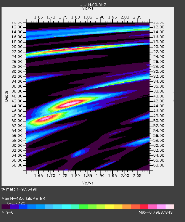
| Estimated Moho Depth: |
43.0 km |
| Estimated Crust Vp/Vs: |
1.77 |
| Assumed Crust Vp: |
6.642 km/s |
| Estimated Crust Vs: |
3.747 km/s |
| Estimated Crust Poisson's Ratio: |
0.27 |
|
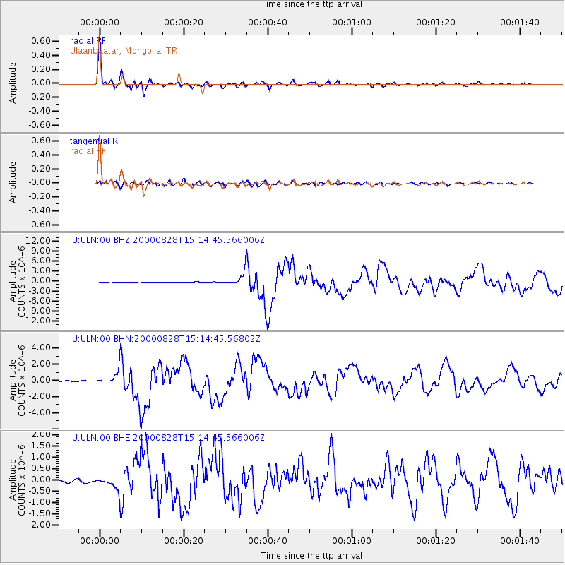
| Radial Match: |
97.5499 % |
| Radial Bump: |
352 |
| Transverse Match: |
87.87218 % |
| Transverse Bump: |
400 |
| SOD ConfigId: |
3744 |
| Insert Time: |
2010-03-03 16:14:59.215 +0000 |
| GWidth: |
2.5 |
| Max Bumps: |
400 |
| Tol: |
0.001 |
|
Signal To Noise
| Channel | StoN | STA | LTA |
| IU:ULN:00:BHN:20000828T15:14:45.56802Z | 18.668877 | 8.615263E-7 | 4.614773E-8 |
| IU:ULN:00:BHE:20000828T15:14:45.566006Z | 5.741505 | 2.9408818E-7 | 5.1221445E-8 |
| IU:ULN:00:BHZ:20000828T15:14:45.566006Z | 35.2828 | 1.9476959E-6 | 5.520242E-8 |
| Arrivals |
| Ps | 5.3 SECOND |
| PpPs | 17 SECOND |
| PsPs/PpSs | 22 SECOND |


