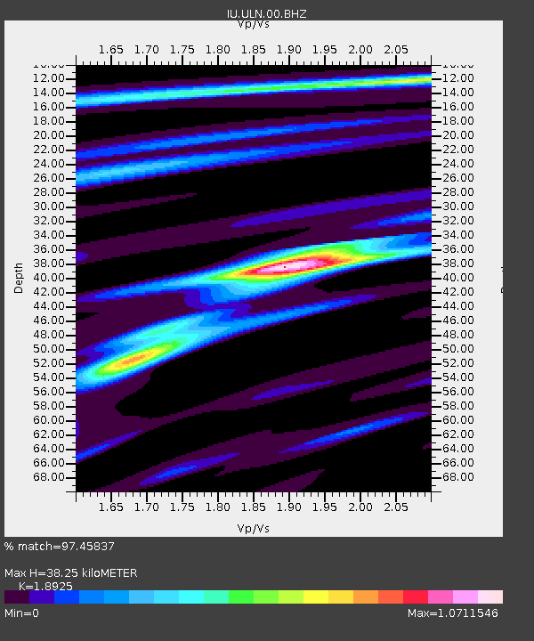
ULN Ulaanbaatar, Mongolia - Earthquake Result Viewer

Earthquake location: New Britain Region, P.N.G.
Earthquake latitude/longitude: -5.1/152.5
Earthquake time(UTC): 2000/06/09 (161) 01:27:15 GMT
Earthquake Depth: 33 km
Earthquake Magnitude: 5.4 MB, 6.3 MS, 6.3 MW, 6.3 MW
Earthquake Catalog/Contributor: WHDF/NEIC
Network: IU Global Seismograph Network (GSN - IRIS/USGS)
Station: ULN Ulaanbaatar, Mongolia
Lat/Lon: 47.87 N/107.05 E
Elevation: 1610 m
Distance: 66.1 deg
Az: 328.336 deg
Baz: 129.053 deg
Ray Param: 0.057808403
Estimated Moho Depth: 38.25 km
Estimated Crust Vp/Vs: 1.89
Assumed Crust Vp: 6.642 km/s
Estimated Crust Vs: 3.51 km/s
Estimated Crust Poisson's Ratio: 0.31
Radial Match: 97.45837 %
Radial Bump: 230
Transverse Match: 81.88715 %
Transverse Bump: 400
SOD ConfigId: 3744
Insert Time: 2010-03-03 16:15:13.970 +0000
GWidth: 2.5
Max Bumps: 400
Tol: 0.001

Signal To Noise

ChannelStoNSTALTA
IU:ULN:00:BHN:20000609T01:37:27.940029Z4.96526157.713518E-81.5534967E-8
IU:ULN:00:BHE:20000609T01:37:27.940029Z2.6579396.3052305E-82.3722254E-8
IU:ULN:00:BHZ:20000609T01:37:27.940029Z8.0076322.475966E-73.0920074E-8
Arrivals
Ps5.4 SECOND
PpPs16 SECOND
PsPs/PpSs21 SECOND