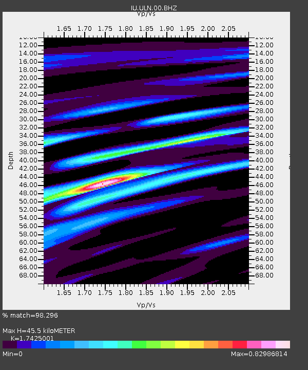
ULN Ulaanbaatar, Mongolia - Earthquake Result Viewer

Earthquake location: Southern Sumatra, Indonesia
Earthquake latitude/longitude: -4.7/102.1
Earthquake time(UTC): 2000/06/04 (156) 16:28:26 GMT
Earthquake Depth: 33 km
Earthquake Magnitude: 6.8 MB, 8.0 MS, 7.9 MW, 7.7 MW
Earthquake Catalog/Contributor: WHDF/NEIC
Network: IU Global Seismograph Network (GSN - IRIS/USGS)
Station: ULN Ulaanbaatar, Mongolia
Lat/Lon: 47.87 N/107.05 E
Elevation: 1610 m
Distance: 52.5 deg
Az: 4.211 deg
Baz: 186.24 deg
Ray Param: 0.06663039
Estimated Moho Depth: 45.5 km
Estimated Crust Vp/Vs: 1.74
Assumed Crust Vp: 6.642 km/s
Estimated Crust Vs: 3.812 km/s
Estimated Crust Poisson's Ratio: 0.25
Radial Match: 98.296 %
Radial Bump: 312
Transverse Match: 86.63716 %
Transverse Bump: 400
SOD ConfigId: 3744
Insert Time: 2010-03-03 16:15:15.269 +0000
GWidth: 2.5
Max Bumps: 400
Tol: 0.001

Signal To Noise

ChannelStoNSTALTA
IU:ULN:00:BHN:20000604T16:37:05.711016Z1.87525657.8049686E-74.1620808E-7
IU:ULN:00:BHE:20000604T16:37:05.711016Z1.45852031.1071668E-77.591027E-8
IU:ULN:00:BHZ:20000604T16:37:05.709001Z1.78181041.1812888E-66.629711E-7
Arrivals
Ps5.4 SECOND
PpPs18 SECOND
PsPs/PpSs23 SECOND