You are here: Home > Network List > TA - USArray Transportable Network (new EarthScope stations) Stations List
> Station F61A St Evariste, QC, CAN > Earthquake Result Viewer
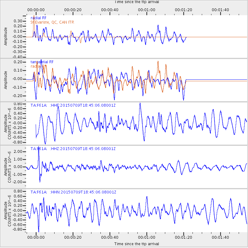
F61A St Evariste, QC, CAN - Earthquake Result Viewer
*The percent match for this event was below the threshold and hence no stack was calculated.
| Earthquake location: |
Near East Coast Of Honshu, Japan |
| Earthquake latitude/longitude: |
40.4/141.5 |
| Earthquake time(UTC): |
2015/07/09 (190) 18:32:51 GMT |
| Earthquake Depth: |
79 km |
| Earthquake Magnitude: |
5.6 MWB, 5.5 MWW, 5.6 MWR, 5.6 MWC |
| Earthquake Catalog/Contributor: |
NEIC PDE/NEIC COMCAT |
|
| Network: |
TA USArray Transportable Network (new EarthScope stations) |
| Station: |
F61A St Evariste, QC, CAN |
| Lat/Lon: |
45.97 N/70.99 W |
| Elevation: |
350 m |
|
| Distance: |
89.3 deg |
| Az: |
21.989 deg |
| Baz: |
335.78 deg |
| Ray Param: |
$rayparam |
*The percent match for this event was below the threshold and hence was not used in the summary stack. |
|
| Radial Match: |
59.50673 % |
| Radial Bump: |
359 |
| Transverse Match: |
60.81811 % |
| Transverse Bump: |
400 |
| SOD ConfigId: |
7422571 |
| Insert Time: |
2019-04-19 18:08:24.474 +0000 |
| GWidth: |
2.5 |
| Max Bumps: |
400 |
| Tol: |
0.001 |
|
Signal To Noise
| Channel | StoN | STA | LTA |
| TA:F61A: :HHZ:20150709T18:45:06.08001Z | 4.8335814 | 9.2675265E-7 | 1.917321E-7 |
| TA:F61A: :HHN:20150709T18:45:06.08001Z | 0.96815217 | 3.1731258E-7 | 3.2775074E-7 |
| TA:F61A: :HHE:20150709T18:45:06.08001Z | 0.52067983 | 1.7718908E-7 | 3.4030333E-7 |
| Arrivals |
| Ps | |
| PpPs | |
| PsPs/PpSs | |


