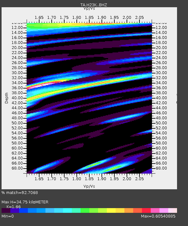
H23K Yukon River, AK, USA - Earthquake Result Viewer

Earthquake location: Near East Coast Of Honshu, Japan
Earthquake latitude/longitude: 40.4/141.5
Earthquake time(UTC): 2015/07/09 (190) 18:32:51 GMT
Earthquake Depth: 79 km
Earthquake Magnitude: 5.6 MWB, 5.5 MWW, 5.6 MWR, 5.6 MWC
Earthquake Catalog/Contributor: NEIC PDE/NEIC COMCAT
Network: TA USArray Transportable Network (new EarthScope stations)
Station: H23K Yukon River, AK, USA
Lat/Lon: 65.83 N/149.54 W
Elevation: 617 m
Distance: 45.5 deg
Az: 32.604 deg
Baz: 271.277 deg
Ray Param: 0.070972435
Estimated Moho Depth: 34.75 km
Estimated Crust Vp/Vs: 1.66
Assumed Crust Vp: 6.566 km/s
Estimated Crust Vs: 3.956 km/s
Estimated Crust Poisson's Ratio: 0.22
Radial Match: 92.7068 %
Radial Bump: 400
Transverse Match: 82.65039 %
Transverse Bump: 400
SOD ConfigId: 7422571
Insert Time: 2019-04-19 18:08:33.454 +0000
GWidth: 2.5
Max Bumps: 400
Tol: 0.001

Signal To Noise

ChannelStoNSTALTA
TA:H23K: :BHZ:20150709T18:40:31.349999Z28.04712.2423012E-67.99477E-8
TA:H23K: :BHN:20150709T18:40:31.349999Z3.90540622.2653748E-75.8006123E-8
TA:H23K: :BHE:20150709T18:40:31.349999Z23.2088159.3831835E-74.0429395E-8
Arrivals
Ps3.7 SECOND
PpPs13 SECOND
PsPs/PpSs17 SECOND