You are here: Home > Network List > TA - USArray Transportable Network (new EarthScope stations) Stations List
> Station H63A New Sharon, ME, USA > Earthquake Result Viewer
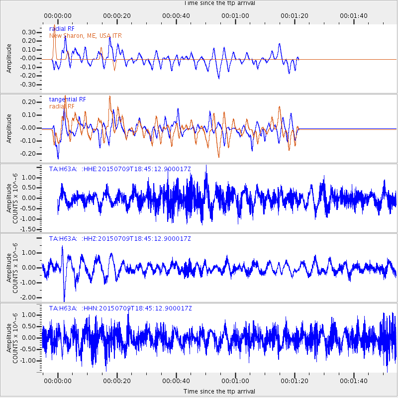
H63A New Sharon, ME, USA - Earthquake Result Viewer
*The percent match for this event was below the threshold and hence no stack was calculated.
| Earthquake location: |
Near East Coast Of Honshu, Japan |
| Earthquake latitude/longitude: |
40.4/141.5 |
| Earthquake time(UTC): |
2015/07/09 (190) 18:32:51 GMT |
| Earthquake Depth: |
79 km |
| Earthquake Magnitude: |
5.6 MWB, 5.5 MWW, 5.6 MWR, 5.6 MWC |
| Earthquake Catalog/Contributor: |
NEIC PDE/NEIC COMCAT |
|
| Network: |
TA USArray Transportable Network (new EarthScope stations) |
| Station: |
H63A New Sharon, ME, USA |
| Lat/Lon: |
44.66 N/70.04 W |
| Elevation: |
109 m |
|
| Distance: |
90.7 deg |
| Az: |
21.904 deg |
| Baz: |
336.458 deg |
| Ray Param: |
$rayparam |
*The percent match for this event was below the threshold and hence was not used in the summary stack. |
|
| Radial Match: |
56.32077 % |
| Radial Bump: |
386 |
| Transverse Match: |
65.51215 % |
| Transverse Bump: |
339 |
| SOD ConfigId: |
7422571 |
| Insert Time: |
2019-04-19 18:08:39.249 +0000 |
| GWidth: |
2.5 |
| Max Bumps: |
400 |
| Tol: |
0.001 |
|
Signal To Noise
| Channel | StoN | STA | LTA |
| TA:H63A: :HHZ:20150709T18:45:12.900017Z | 2.1808913 | 7.834898E-7 | 3.592521E-7 |
| TA:H63A: :HHN:20150709T18:45:12.900017Z | 1.1218044 | 3.7542299E-7 | 3.3465997E-7 |
| TA:H63A: :HHE:20150709T18:45:12.900017Z | 1.5018986 | 4.0234588E-7 | 2.678915E-7 |
| Arrivals |
| Ps | |
| PpPs | |
| PsPs/PpSs | |


