You are here: Home > Network List > TA - USArray Transportable Network (new EarthScope stations) Stations List
> Station J01E Myrtle Point, OR, USA > Earthquake Result Viewer
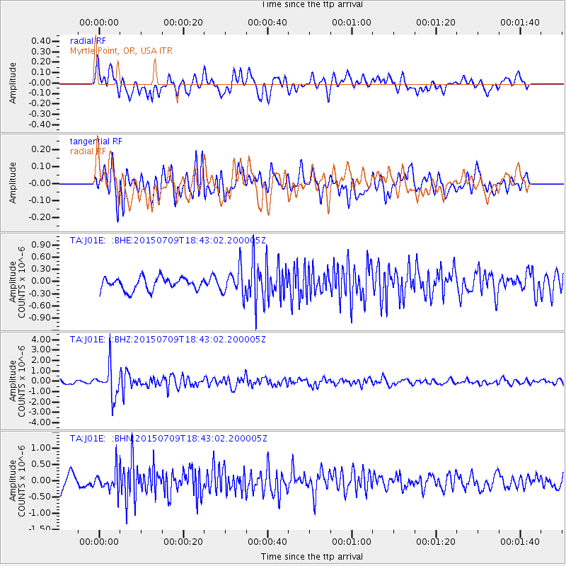
J01E Myrtle Point, OR, USA - Earthquake Result Viewer
*The percent match for this event was below the threshold and hence no stack was calculated.
| Earthquake location: |
Near East Coast Of Honshu, Japan |
| Earthquake latitude/longitude: |
40.4/141.5 |
| Earthquake time(UTC): |
2015/07/09 (190) 18:32:51 GMT |
| Earthquake Depth: |
79 km |
| Earthquake Magnitude: |
5.6 MWB, 5.5 MWW, 5.6 MWR, 5.6 MWC |
| Earthquake Catalog/Contributor: |
NEIC PDE/NEIC COMCAT |
|
| Network: |
TA USArray Transportable Network (new EarthScope stations) |
| Station: |
J01E Myrtle Point, OR, USA |
| Lat/Lon: |
43.16 N/123.93 W |
| Elevation: |
128 m |
|
| Distance: |
66.7 deg |
| Az: |
52.554 deg |
| Baz: |
304.0 deg |
| Ray Param: |
$rayparam |
*The percent match for this event was below the threshold and hence was not used in the summary stack. |
|
| Radial Match: |
68.87351 % |
| Radial Bump: |
400 |
| Transverse Match: |
64.745445 % |
| Transverse Bump: |
400 |
| SOD ConfigId: |
7422571 |
| Insert Time: |
2019-04-19 18:08:50.178 +0000 |
| GWidth: |
2.5 |
| Max Bumps: |
400 |
| Tol: |
0.001 |
|
Signal To Noise
| Channel | StoN | STA | LTA |
| TA:J01E: :BHZ:20150709T18:43:02.200005Z | 9.301372 | 1.5397097E-6 | 1.6553578E-7 |
| TA:J01E: :BHN:20150709T18:43:02.200005Z | 1.6580492 | 3.4851254E-7 | 2.1019433E-7 |
| TA:J01E: :BHE:20150709T18:43:02.200005Z | 2.1909623 | 3.2454147E-7 | 1.4812737E-7 |
| Arrivals |
| Ps | |
| PpPs | |
| PsPs/PpSs | |


