You are here: Home > Network List > TA - USArray Transportable Network (new EarthScope stations) Stations List
> Station L04D Klamath Falls, OR, USA > Earthquake Result Viewer
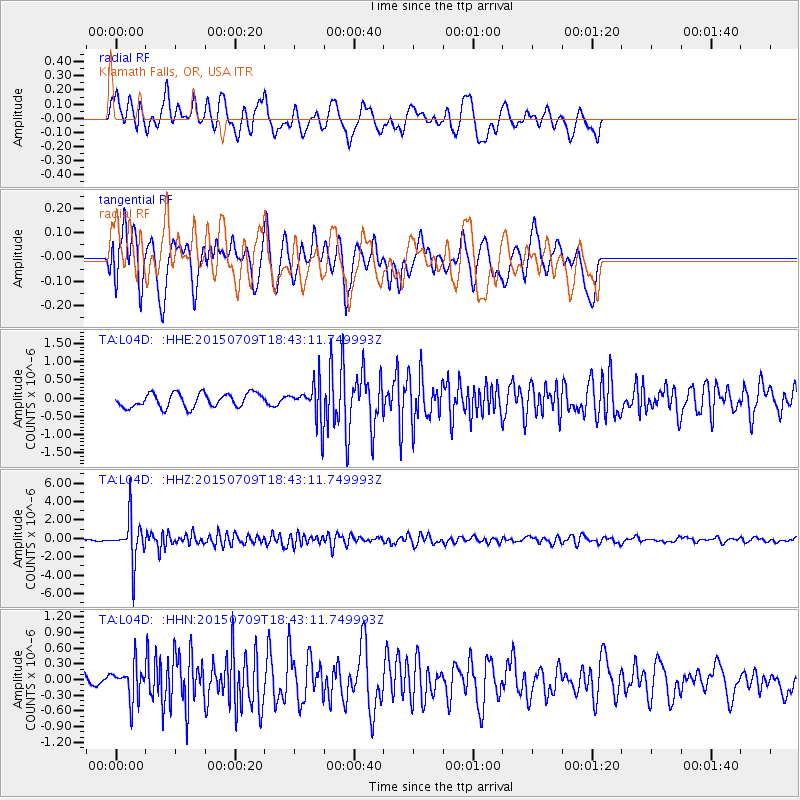
L04D Klamath Falls, OR, USA - Earthquake Result Viewer
*The percent match for this event was below the threshold and hence no stack was calculated.
| Earthquake location: |
Near East Coast Of Honshu, Japan |
| Earthquake latitude/longitude: |
40.4/141.5 |
| Earthquake time(UTC): |
2015/07/09 (190) 18:32:51 GMT |
| Earthquake Depth: |
79 km |
| Earthquake Magnitude: |
5.6 MWB, 5.5 MWW, 5.6 MWR, 5.6 MWC |
| Earthquake Catalog/Contributor: |
NEIC PDE/NEIC COMCAT |
|
| Network: |
TA USArray Transportable Network (new EarthScope stations) |
| Station: |
L04D Klamath Falls, OR, USA |
| Lat/Lon: |
42.22 N/122.30 W |
| Elevation: |
1437 m |
|
| Distance: |
68.3 deg |
| Az: |
52.657 deg |
| Baz: |
305.139 deg |
| Ray Param: |
$rayparam |
*The percent match for this event was below the threshold and hence was not used in the summary stack. |
|
| Radial Match: |
75.87726 % |
| Radial Bump: |
400 |
| Transverse Match: |
66.43698 % |
| Transverse Bump: |
400 |
| SOD ConfigId: |
7422571 |
| Insert Time: |
2019-04-19 18:09:02.291 +0000 |
| GWidth: |
2.5 |
| Max Bumps: |
400 |
| Tol: |
0.001 |
|
Signal To Noise
| Channel | StoN | STA | LTA |
| TA:L04D: :HHZ:20150709T18:43:11.749993Z | 36.322395 | 2.3684463E-6 | 6.520622E-8 |
| TA:L04D: :HHN:20150709T18:43:11.749993Z | 2.2871583 | 3.2566382E-7 | 1.4238798E-7 |
| TA:L04D: :HHE:20150709T18:43:11.749993Z | 3.0043364 | 5.7515575E-7 | 1.9144186E-7 |
| Arrivals |
| Ps | |
| PpPs | |
| PsPs/PpSs | |


