ULN Ulaanbaatar, Mongolia - Earthquake Result Viewer
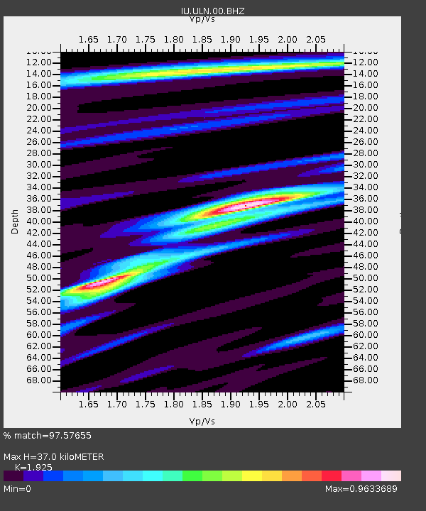
Earthquake location: New Britain Region, P.N.G.
Earthquake latitude/longitude: -4.2/152.7
Earthquake time(UTC): 2000/12/06 (341) 22:57:40 GMT
Earthquake Depth: 31 km
Earthquake Magnitude: 6.1 MB, 6.6 MS, 6.6 MW, 6.2 ME
Earthquake Catalog/Contributor: WHDF/NEIC
Network: IU Global Seismograph Network (GSN - IRIS/USGS)
Station: ULN Ulaanbaatar, Mongolia
Lat/Lon: 47.87 N/107.05 E
Elevation: 1610 m
Distance: 65.5 deg
Az: 328.029 deg
Baz: 128.349 deg
Ray Param: 0.058205854
Estimated Moho Depth: 37.0 km
Estimated Crust Vp/Vs: 1.92
Assumed Crust Vp: 6.642 km/s
Estimated Crust Vs: 3.45 km/s
Estimated Crust Poisson's Ratio: 0.32
Radial Match: 97.57655 %
Radial Bump: 294
Transverse Match: 82.633484 %
Transverse Bump: 400
SOD ConfigId: 3744
Insert Time: 2010-03-03 16:15:37.529 +0000
GWidth: 2.5
Max Bumps: 400
Tol: 0.001

Signal To Noise

ChannelStoNSTALTA
IU:ULN:00:BHN:20001206T23:07:49.180015Z5.1906582.2552096E-74.344747E-8
IU:ULN:00:BHE:20001206T23:07:49.180015Z4.6794352.838678E-76.0662835E-8
IU:ULN:00:BHZ:20001206T23:07:49.180015Z8.4018267.770929E-79.249096E-8
Arrivals
Ps5.4 SECOND
PpPs16 SECOND
PsPs/PpSs21 SECOND