You are here: Home > Network List > TA - USArray Transportable Network (new EarthScope stations) Stations List
> Station N23A Red Feather Lakes, CO, USA > Earthquake Result Viewer
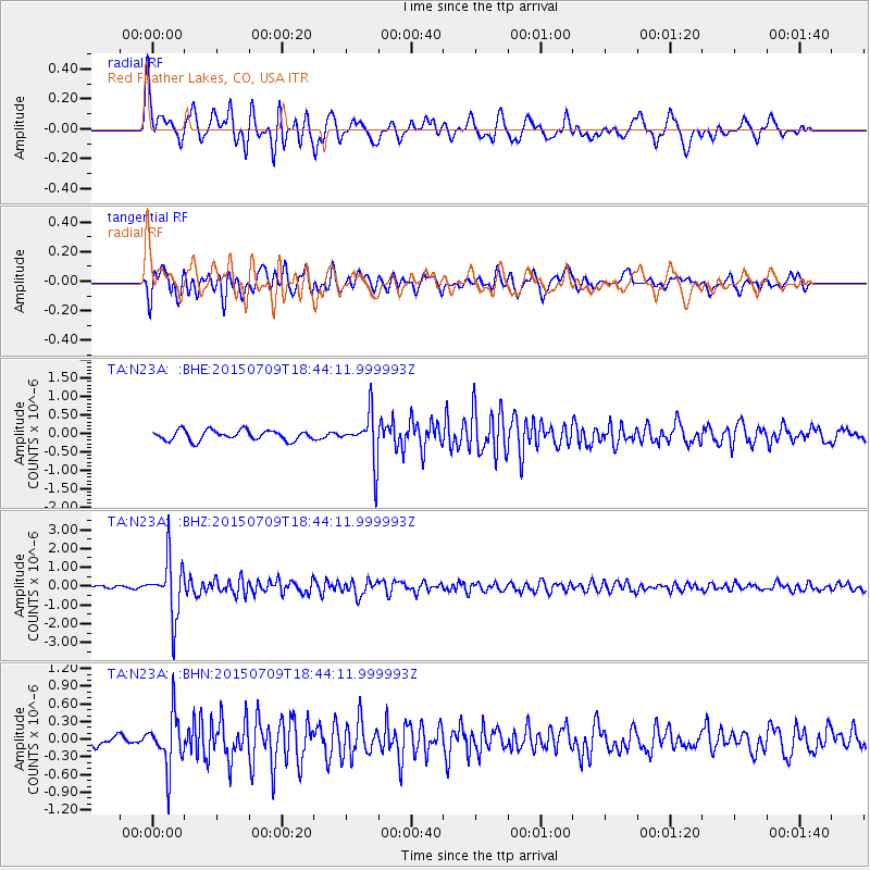
N23A Red Feather Lakes, CO, USA - Earthquake Result Viewer
*The percent match for this event was below the threshold and hence no stack was calculated.
| Earthquake location: |
Near East Coast Of Honshu, Japan |
| Earthquake latitude/longitude: |
40.4/141.5 |
| Earthquake time(UTC): |
2015/07/09 (190) 18:32:51 GMT |
| Earthquake Depth: |
79 km |
| Earthquake Magnitude: |
5.6 MWB, 5.5 MWW, 5.6 MWR, 5.6 MWC |
| Earthquake Catalog/Contributor: |
NEIC PDE/NEIC COMCAT |
|
| Network: |
TA USArray Transportable Network (new EarthScope stations) |
| Station: |
N23A Red Feather Lakes, CO, USA |
| Lat/Lon: |
40.89 N/105.94 W |
| Elevation: |
2458 m |
|
| Distance: |
78.6 deg |
| Az: |
45.575 deg |
| Baz: |
313.96 deg |
| Ray Param: |
$rayparam |
*The percent match for this event was below the threshold and hence was not used in the summary stack. |
|
| Radial Match: |
71.5813 % |
| Radial Bump: |
400 |
| Transverse Match: |
74.8746 % |
| Transverse Bump: |
400 |
| SOD ConfigId: |
7422571 |
| Insert Time: |
2019-04-19 18:09:17.077 +0000 |
| GWidth: |
2.5 |
| Max Bumps: |
400 |
| Tol: |
0.001 |
|
Signal To Noise
| Channel | StoN | STA | LTA |
| TA:N23A: :BHZ:20150709T18:44:11.999993Z | 11.567345 | 1.514619E-6 | 1.3093921E-7 |
| TA:N23A: :BHN:20150709T18:44:11.999993Z | 4.4036674 | 4.4982193E-7 | 1.0214711E-7 |
| TA:N23A: :BHE:20150709T18:44:11.999993Z | 4.777191 | 6.56974E-7 | 1.3752307E-7 |
| Arrivals |
| Ps | |
| PpPs | |
| PsPs/PpSs | |


