You are here: Home > Network List > UW - Pacific Northwest Regional Seismic Network Stations List
> Station PASS Maple Falls, WA, USA > Earthquake Result Viewer
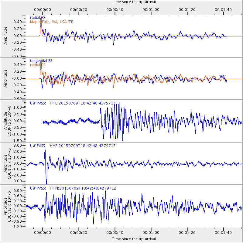
PASS Maple Falls, WA, USA - Earthquake Result Viewer
*The percent match for this event was below the threshold and hence no stack was calculated.
| Earthquake location: |
Near East Coast Of Honshu, Japan |
| Earthquake latitude/longitude: |
40.4/141.5 |
| Earthquake time(UTC): |
2015/07/09 (190) 18:32:51 GMT |
| Earthquake Depth: |
79 km |
| Earthquake Magnitude: |
5.6 MWB, 5.5 MWW, 5.6 MWR, 5.6 MWC |
| Earthquake Catalog/Contributor: |
NEIC PDE/NEIC COMCAT |
|
| Network: |
UW Pacific Northwest Regional Seismic Network |
| Station: |
PASS Maple Falls, WA, USA |
| Lat/Lon: |
49.00 N/122.09 W |
| Elevation: |
174 m |
|
| Distance: |
64.6 deg |
| Az: |
46.428 deg |
| Baz: |
302.8 deg |
| Ray Param: |
$rayparam |
*The percent match for this event was below the threshold and hence was not used in the summary stack. |
|
| Radial Match: |
78.666794 % |
| Radial Bump: |
400 |
| Transverse Match: |
71.614655 % |
| Transverse Bump: |
400 |
| SOD ConfigId: |
7422571 |
| Insert Time: |
2019-04-19 18:10:48.811 +0000 |
| GWidth: |
2.5 |
| Max Bumps: |
400 |
| Tol: |
0.001 |
|
Signal To Noise
| Channel | StoN | STA | LTA |
| UW:PASS: :HHZ:20150709T18:42:48.427971Z | 8.469253 | 1.2565057E-6 | 1.4836087E-7 |
| UW:PASS: :HHN:20150709T18:42:48.427971Z | 2.7867844 | 3.5784262E-7 | 1.28407E-7 |
| UW:PASS: :HHE:20150709T18:42:48.427971Z | 4.875775 | 5.2699573E-7 | 1.08084514E-7 |
| Arrivals |
| Ps | |
| PpPs | |
| PsPs/PpSs | |


