You are here: Home > Network List > IU - Global Seismograph Network (GSN - IRIS/USGS) Stations List
> Station ULN Ulaanbaatar, Mongolia > Earthquake Result Viewer
ULN Ulaanbaatar, Mongolia - Earthquake Result Viewer
| Earthquake location: |
Northern Molucca Sea |
| Earthquake latitude/longitude: |
1.3/126.2 |
| Earthquake time(UTC): |
2001/02/24 (055) 07:23:48 GMT |
| Earthquake Depth: |
35 km |
| Earthquake Magnitude: |
6.6 MB, 7.0 MS, 7.1 MW, 7.1 ME |
| Earthquake Catalog/Contributor: |
WHDF/NEIC |
|
| Network: |
IU Global Seismograph Network (GSN - IRIS/USGS) |
| Station: |
ULN Ulaanbaatar, Mongolia |
| Lat/Lon: |
47.87 N/107.05 E |
| Elevation: |
1610 m |
|
| Distance: |
49.3 deg |
| Az: |
343.022 deg |
| Baz: |
154.306 deg |
| Ray Param: |
0.0687176 |
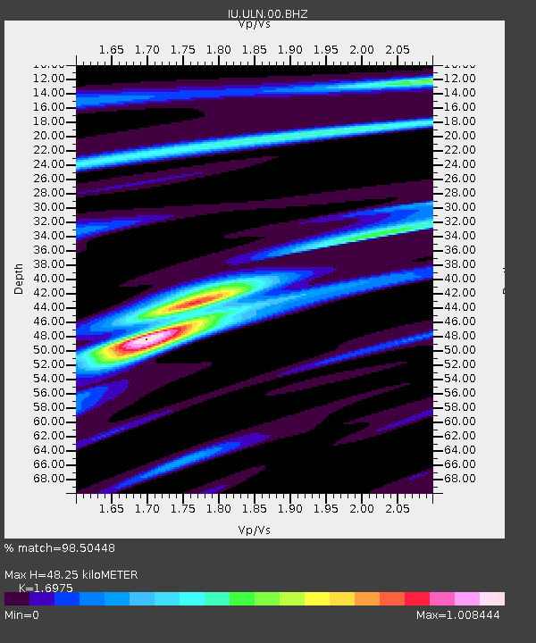
| Estimated Moho Depth: |
48.25 km |
| Estimated Crust Vp/Vs: |
1.70 |
| Assumed Crust Vp: |
6.642 km/s |
| Estimated Crust Vs: |
3.913 km/s |
| Estimated Crust Poisson's Ratio: |
0.23 |
|
| Radial Match: |
98.50448 % |
| Radial Bump: |
345 |
| Transverse Match: |
91.07896 % |
| Transverse Bump: |
400 |
| SOD ConfigId: |
3744 |
| Insert Time: |
2010-03-03 16:17:47.782 +0000 |
| GWidth: |
2.5 |
| Max Bumps: |
400 |
| Tol: |
0.001 |
|
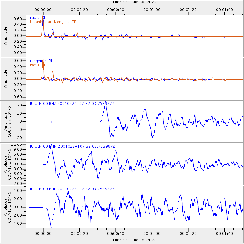
Signal To Noise
| Channel | StoN | STA | LTA |
| IU:ULN:00:BHN:20010224T07:32:03.753987Z | 79.68339 | 5.5234614E-6 | 6.93176E-8 |
| IU:ULN:00:BHE:20010224T07:32:03.753987Z | 33.23497 | 2.158779E-6 | 6.4955046E-8 |
| IU:ULN:00:BHZ:20010224T07:32:03.753987Z | 134.34181 | 1.0972799E-5 | 8.1678216E-8 |
| Arrivals |
| Ps | 5.4 SECOND |
| PpPs | 18 SECOND |
| PsPs/PpSs | 24 SECOND |


