You are here: Home > Network List > AK - Alaska Regional Network Stations List
> Station BCP Bancas Point, AK, USA > Earthquake Result Viewer
BCP Bancas Point, AK, USA - Earthquake Result Viewer
| Earthquake location: |
Solomon Islands |
| Earthquake latitude/longitude: |
-9.3/158.4 |
| Earthquake time(UTC): |
2015/07/10 (191) 04:12:41 GMT |
| Earthquake Depth: |
10 km |
| Earthquake Magnitude: |
6.7 MWW, 6.6 MWB, 6.7 MWC, 7.0 MI |
| Earthquake Catalog/Contributor: |
NEIC PDE/NEIC COMCAT |
|
| Network: |
AK Alaska Regional Network |
| Station: |
BCP Bancas Point, AK, USA |
| Lat/Lon: |
59.95 N/139.63 W |
| Elevation: |
422 m |
|
| Distance: |
84.6 deg |
| Az: |
26.492 deg |
| Baz: |
241.035 deg |
| Ray Param: |
0.04539029 |
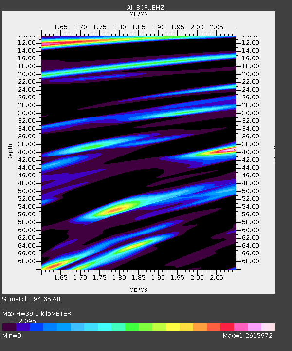
| Estimated Moho Depth: |
39.0 km |
| Estimated Crust Vp/Vs: |
2.10 |
| Assumed Crust Vp: |
6.183 km/s |
| Estimated Crust Vs: |
2.951 km/s |
| Estimated Crust Poisson's Ratio: |
0.35 |
|
| Radial Match: |
94.65748 % |
| Radial Bump: |
367 |
| Transverse Match: |
89.874374 % |
| Transverse Bump: |
400 |
| SOD ConfigId: |
7422571 |
| Insert Time: |
2019-04-19 18:22:21.467 +0000 |
| GWidth: |
2.5 |
| Max Bumps: |
400 |
| Tol: |
0.001 |
|

Signal To Noise
| Channel | StoN | STA | LTA |
| AK:BCP: :BHZ:20150710T04:24:43.567981Z | 8.500417 | 8.442942E-7 | 9.932386E-8 |
| AK:BCP: :BHN:20150710T04:24:43.567981Z | 1.7536062 | 2.0293935E-7 | 1.1572686E-7 |
| AK:BCP: :BHE:20150710T04:24:43.567981Z | 3.429606 | 2.5840328E-7 | 7.534489E-8 |
| Arrivals |
| Ps | 7.0 SECOND |
| PpPs | 19 SECOND |
| PsPs/PpSs | 26 SECOND |


