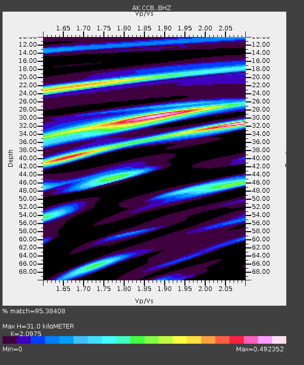
CCB Clear Creek Butte - Earthquake Result Viewer

Earthquake location: Solomon Islands
Earthquake latitude/longitude: -9.3/158.4
Earthquake time(UTC): 2015/07/10 (191) 04:12:41 GMT
Earthquake Depth: 10 km
Earthquake Magnitude: 6.7 MWW, 6.6 MWB, 6.7 MWC, 7.0 MI
Earthquake Catalog/Contributor: NEIC PDE/NEIC COMCAT
Network: AK Alaska Regional Network
Station: CCB Clear Creek Butte
Lat/Lon: 64.65 N/147.80 W
Elevation: 248 m
Distance: 83.9 deg
Az: 20.445 deg
Baz: 233.198 deg
Ray Param: 0.045849122
Estimated Moho Depth: 31.0 km
Estimated Crust Vp/Vs: 2.10
Assumed Crust Vp: 6.566 km/s
Estimated Crust Vs: 3.13 km/s
Estimated Crust Poisson's Ratio: 0.35
Radial Match: 95.38408 %
Radial Bump: 340
Transverse Match: 83.69364 %
Transverse Bump: 400
SOD ConfigId: 7422571
Insert Time: 2019-04-19 18:22:30.754 +0000
GWidth: 2.5
Max Bumps: 400
Tol: 0.001

Signal To Noise

ChannelStoNSTALTA
AK:CCB: :BHZ:20150710T04:24:40.228015Z23.7598061.601348E-66.739735E-8
AK:CCB: :BHN:20150710T04:24:40.228015Z3.26887683.0384467E-79.295079E-8
AK:CCB: :BHE:20150710T04:24:40.228015Z7.48935565.198516E-76.941206E-8
Arrivals
Ps5.3 SECOND
PpPs14 SECOND
PsPs/PpSs20 SECOND