You are here: Home > Network List > AK - Alaska Regional Network Stations List
> Station KLU Klutina Pass, Alaska, USA > Earthquake Result Viewer
KLU Klutina Pass, Alaska, USA - Earthquake Result Viewer
| Earthquake location: |
Solomon Islands |
| Earthquake latitude/longitude: |
-9.3/158.4 |
| Earthquake time(UTC): |
2015/07/10 (191) 04:12:41 GMT |
| Earthquake Depth: |
10 km |
| Earthquake Magnitude: |
6.7 MWW, 6.6 MWB, 6.7 MWC, 7.0 MI |
| Earthquake Catalog/Contributor: |
NEIC PDE/NEIC COMCAT |
|
| Network: |
AK Alaska Regional Network |
| Station: |
KLU Klutina Pass, Alaska, USA |
| Lat/Lon: |
61.49 N/145.92 W |
| Elevation: |
1021 m |
|
| Distance: |
82.8 deg |
| Az: |
23.534 deg |
| Baz: |
235.233 deg |
| Ray Param: |
0.04666493 |
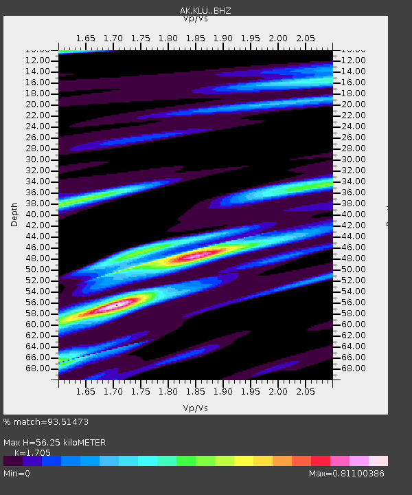
| Estimated Moho Depth: |
56.25 km |
| Estimated Crust Vp/Vs: |
1.71 |
| Assumed Crust Vp: |
6.566 km/s |
| Estimated Crust Vs: |
3.851 km/s |
| Estimated Crust Poisson's Ratio: |
0.24 |
|
| Radial Match: |
93.51473 % |
| Radial Bump: |
310 |
| Transverse Match: |
90.49174 % |
| Transverse Bump: |
400 |
| SOD ConfigId: |
7422571 |
| Insert Time: |
2019-04-19 18:22:52.604 +0000 |
| GWidth: |
2.5 |
| Max Bumps: |
400 |
| Tol: |
0.001 |
|

Signal To Noise
| Channel | StoN | STA | LTA |
| AK:KLU: :BHZ:20150710T04:24:34.327991Z | 13.549144 | 9.844075E-7 | 7.265459E-8 |
| AK:KLU: :BHN:20150710T04:24:34.327991Z | 3.7102897 | 2.3250803E-7 | 6.2665734E-8 |
| AK:KLU: :BHE:20150710T04:24:34.327991Z | 6.63226 | 3.402877E-7 | 5.1307953E-8 |
| Arrivals |
| Ps | 6.2 SECOND |
| PpPs | 23 SECOND |
| PsPs/PpSs | 29 SECOND |


