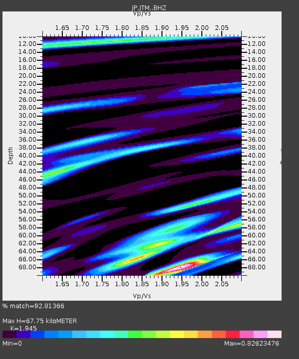
JTM Aomori Tenma - Earthquake Result Viewer

Earthquake location: Solomon Islands
Earthquake latitude/longitude: -9.3/158.4
Earthquake time(UTC): 2015/07/10 (191) 04:12:41 GMT
Earthquake Depth: 10 km
Earthquake Magnitude: 6.7 MWW, 6.6 MWB, 6.7 MWC, 7.0 MI
Earthquake Catalog/Contributor: NEIC PDE/NEIC COMCAT
Network: JP Japan Meteorological Agency Seismic Network
Station: JTM Aomori Tenma
Lat/Lon: 40.79 N/141.06 E
Elevation: 130 m
Distance: 52.4 deg
Az: 343.378 deg
Baz: 158.17 deg
Ray Param: 0.06680663
Estimated Moho Depth: 67.75 km
Estimated Crust Vp/Vs: 1.95
Assumed Crust Vp: 6.468 km/s
Estimated Crust Vs: 3.325 km/s
Estimated Crust Poisson's Ratio: 0.32
Radial Match: 92.81366 %
Radial Bump: 337
Transverse Match: 82.98994 %
Transverse Bump: 400
SOD ConfigId: 7422571
Insert Time: 2019-04-19 18:25:48.256 +0000
GWidth: 2.5
Max Bumps: 400
Tol: 0.001

Signal To Noise

ChannelStoNSTALTA
JP:JTM: :BHZ:20150710T04:21:22.700Z9.036642.2525903E-62.49273E-7
JP:JTM: :BHN:20150710T04:21:22.700Z4.0668961.1004647E-62.7059082E-7
JP:JTM: :BHE:20150710T04:21:22.700Z4.0094524.7098862E-71.17469575E-7
Arrivals
Ps10 SECOND
PpPs29 SECOND
PsPs/PpSs40 SECOND